 Trail
TrailBeaver Ponds on Trail Ridge Road
Beaver wetland boardwalk—0.2 mi, 15 minutes, flat. See sedges, wildlife, ancient dam traces.
Rocky Mountain National ParkView details →
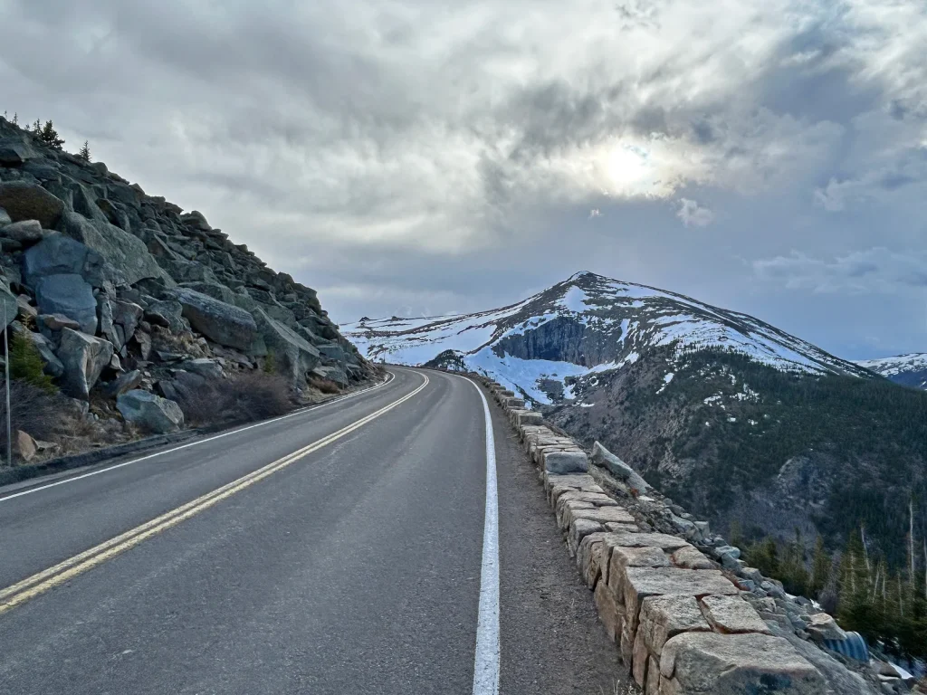
Trail Ridge Road is a 48-mile scenic drive that climbs to 12,183 feet—the highest continuous paved road in the United States. This isn't a casual cruise; altitude and rapidly changing weather demand preparation, but the reward is otherworldly: drive through alpine tundra above the tree line, spot wildlife (elk, bighorn sheep, yellow-bellied marmots), and witness 360-degree views of the Continental Divide from the Alpine Visitor Center at 11,796 feet. For most visitors in good weather (late May–October), this is a doable, non-technical drive that rewards preparation with unmatched high-alpine scenery. Timed entry reservations required; check road status before heading up.
Moderate - Paved drive, high-altitude environment hazards
The highest continuous paved road in the United States. Drive from 7,500 feet to 12,183 feet through alpine tundra. Views of the Continental Divide, glacially-carved valleys, and mountain peaks in all directions. Alpine Visitor Center is the highest elevation visitor center in the National Park Service. Peak season wildflower displays (June–July) on the tundra. Real wildlife encounters: elk herds, bighorn sheep on cliffsides, yellow-bellied marmots sunbathing.
• Road status changes fast—call 970-586-1222 before heading up. Don't assume it's open. • Aim to arrive by 7 AM to beat crowds and reserve the best parking and overlooks. • The Alpine Visitor Center at mile 24 is the true payoff. Even if cloudy, stop here. • Forest Canyon Overlook (descending west side) offers less crowded views and great light for photos at golden hour (late afternoon). • Rock Cut (east side) has the Tundra Communities Trail—a short walk through wildflower meadows in June–July. • Fill your gas tank before starting. Don't assume you can refuel at the summit. • If fog rolls in, slow way down. Visibility can drop to 50 feet instantly. • Bring double the water you think you need. Altitude dehydration is silent. • Don't skip the smaller overlooks. Each offers different angles on the Continental Divide.
Summer and Fall
High altitude requires family preparation. Bring extra water for kids—they dehydrate faster. Snack frequently to maintain energy. Watch children for altitude sickness symptoms: headache, dizziness, nausea. If symptoms appear, descend immediately and rest. Scenic overlooks have guard rails but some have real drop-offs—supervise children. Dress in layers; temperature swings catch families off guard. Plan 1–2 shorter rest breaks if kids are under 10.
Trail Ridge Road is the iconic Colorado alpine scenic drive. Hikers and drivers praise the Continental Divide views, wildflower displays (June–July), and wildlife spotting, but consistently note that high altitude and rapid weather changes demand serious preparation. Crowding peaks in July–August, but the journey rewards those who arrive early and check conditions first.
From late May to mid-October, a timed entry reservation is required to enter all areas of Rocky Mountain National Park during certain times. Visit the RMNP Timed Entry page on Recreation.gov to book your time slot.
N/A - Drive your own vehicle
At 12,183 feet elevation, altitude affects many people—mild headaches, fatigue, nausea are common. Weather changes in minutes. You could be in sunshine and suddenly hit fog with 50-foot visibility. Cold descends fast; temperature can drop 20–30 degrees in an hour. Early/late season may bring surprise snow or ice. Wildlife (elk, bighorn sheep) may cross the road or stand in traffic. Solar radiation at altitude burns skin in minutes. Wind gusts can rock your vehicle.
Paved road with pullouts and scenic overlooks. Flush and vault toilets at multiple stops (Kawuneeche Visitor Center, Milner Pass, Rock Cut, Alpine Visitor Center, Rainbow Curve, Hidden Valley, Beaver Meadows Visitor Center). High altitude (12,183 feet) may affect some visitors; accessible restrooms at visitor centers.
High altitude requires family preparation. Bring extra water for kids—they dehydrate faster. Snack frequently to maintain energy. Watch children for altitude sickness symptoms: headache, dizziness, nausea. If symptoms appear, descend immediately and rest. Scenic overlooks have guard rails but some have real drop-offs—supervise children. Dress in layers; temperature swings catch families off guard. Plan 1–2 shorter rest breaks if kids are under 10.
Alpine Visitor Center (11,796 feet)—restrooms, gift shop, exhibits. Kawuneeche Visitor Center, Rainbow Curve, Rock Cut, Milner Pass have restrooms. No gas stations, restaurants, or food vendors on Trail Ridge Road itself. Fuel and food available at Estes Park (east) or Grand Lake (west) before starting.
Trail Ridge Road is the iconic Colorado alpine scenic drive. Hikers and drivers praise the Continental Divide views, wildflower displays (June–July), and wildlife spotting, but consistently note that high altitude and rapid weather changes demand serious preparation. Crowding peaks in July–August, but the journey rewards those who arrive early and check conditions first.
" Trail Ridge Road is the iconic Colorado alpine scenic drive. Hikers and drivers praise the Continental Divide views, wildflower displays (June–July), and wildlife spotting, but consistently note that high altitude and rapid weather changes demand serious preparation. Crowding peaks in July–August, but the journey rewards those who arrive early and check conditions first."
Yes, but prepare for it. Many first-timers experience mild headaches or fatigue. Start slow, bring 2+ liters of water, avoid alcohol, and don't exert yourself at overlooks. If symptoms worsen (nausea, severe headache), descend immediately and rest. Altitude adjustment takes 1–2 hours for most people.
Yes, it's a well-maintained paved highway. But don't underestimate it. Weather changes fast—fog can roll in and drop visibility to 50 feet in minutes. Always check road status (970-586-1222) before starting, and have a full tank. Temporary closures happen any time due to snow or wind.
It won't trap you mid-drive on a one-way journey. But unexpected closures happen, especially early/late season or during storms. Check the status line and have a backup plan (Old Fall River Road on the east side is an alternate, though rougher). Never assume it's open.
Not in summer—standard vehicle tires are fine on the paved road. Winter (November–May)? The road is closed to through traffic. Illegal off-season attempts require chains, 4WD, and skilled mountain driving. Don't try it.
Budget 2–4 hours depending on stops and crowds. Steady driving is 1.5–2 hours one-way, but you'll want to stop for views and photos. Add 30–60 minutes if timed-entry gate has queues. More if you hike short tundra trails like Tundra Communities at Rock Cut.
No. Fill up at Estes Park (east) or Grand Lake (west) before starting. No gas stations between endpoints. Stock snacks and water for the full drive. Alpine Visitor Center has a gift shop but no food service.
Kids tolerate altitude fine if hydrated and fed. Bring extra water—kids dehydrate faster than adults. Snack frequently (crackers, fruit). Watch for headache, nausea, or tiredness. If symptoms appear, descend and rest. Don't push kids to overlooks if they're tired; rest at the car first.
2 listings
4 listings
Information is compiled from official sources, verified traveler reviews, and editorial research. Learn how YourNPGuide works →
Notifications