Best Photography Spots in Glacier National Park
Seven stunning viewpoints where light, glaciers, and wildlife converge for unforgettable mountain photography.
Glacier National Park straddles the Continental Divide across Montana's northern Rockies, where glacial lakes mirror jagged peaks and meadows ignite with alpine wildflowers. Over 700 miles of trails wind through valleys carved by ice, revealing turquoise water, dramatic shadows, and wildlife at every elevation.
- 1M+ Park acres
- 50 mi Scenic drive
- 6,646 ft Highest overlook
- $35 7-day entry fee
Wild Goose Island Overlook — Going-to-the-Sun Road

Iconic 14-foot island rises from turquoise water with glacier-carved peaks—Glacier's most photographed scene.
- Island focal point creates natural compositional balance against mountain backdrop
- St. Mary Lake turquoise water rivals any alpine lake color
- Accessible roadside pullout, no hiking required
- Early morning alpenglow and sunset golden light deliver warm peak tones
THE ICONIC VIEW
Wild Goose Island is Glacier's most iconic photograph: a 14-foot island rising above turquoise St. Mary Lake, framed by glacier-carved peaks. Accessible from a Going-to-the-Sun Road pullout with no hiking, this view made Glacier famous. The island's small size creates instant compositional balance; center the island in the frame and let the peaks anchor the composition.
The turquoise water comes from glacial flour suspended in snowmelt. Reflection quality peaks in calm, clear mornings. Early morning light delivers cool alpenglow on peaks; late afternoon sun angles lower, reducing glare on the water surface.
CROWDS & TIMING
This pullout fills by 8:30 AM during peak July–August. Arrive before sunrise or after 4 PM for solitude. July 1–Sept 7, use the free Going-to-the-Sun Road shuttle service (tickets on Recreation.gov) to avoid parking stress entirely.
September brings significantly fewer crowds and cooler light. October offers larch golden color. Avoid 10 AM–3 PM harsh overhead light, which flattens color and washes out the turquoise.
GEAR & TECHNIQUE
Wide-angle lens (17–35mm) captures the full island-peak composition. A polarizing filter is essential: it cuts water glare, deepens the turquoise, and reveals reflection detail. ND filter enables long-exposure silky water if desired. Tripod stabilizes the shot and forces deliberate composition.
Sunrise: cool blue light on peaks, warm orange sky. Sunset: reversed. Both deliver strong alpenglow. Spring runoff (May–June) delivers clearest, brightest turquoise water. Summer algae may slightly reduce clarity; autumn water is exceptional.
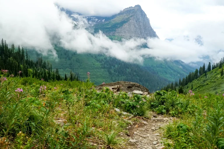
Logan Pass — Continental Divide
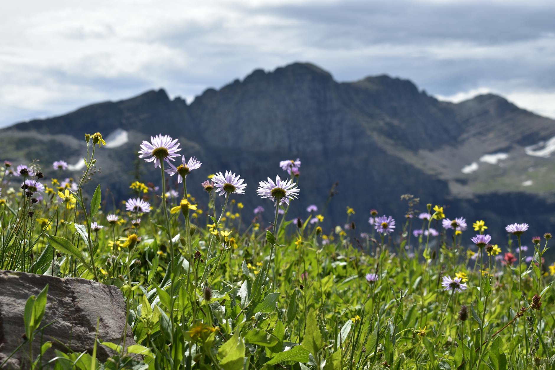
Alpine meadows burst with wildflowers at 6,646 feet; bighorn sheep roam, peaks frame dramatic light.
- Reynolds and Clements Mountains tower over wildflower fields mid-July through August
- Bighorn sheep and mountain goats frequent the area; prime wildlife photography location
- 360-degree mountain views from Continental Divide; dramatic early-morning peak shadows
- Visitor center, drinking water, ranger programs, complimentary shuttle (July 1–Sept 7, 2026)
ALPINE WILDFLOWERS
Logan Pass (6,646 ft) straddles the Continental Divide and serves as Glacier's alpine garden. Reynolds and Clements Mountains tower above meadows filled with glacier lilies (June), beargrass (July), Indian paintbrush, and columbine (July–August). Peak bloom timing varies year to year based on snowmelt; mid-July through early August is most reliable.
Wildflowers frame mountain vistas in low, warm morning light. Shoot downward to capture wildflower detail with peak backdrop. Use 35–70mm focal length to balance foreground flowers and distant mountains. Polarizing filter reduces sky glare and deepens cloud contrast.
WILDLIFE & LIGHT
Mountain goats and bighorn sheep are frequently visible in early morning (before 8 AM). They graze meadows and rocky slopes. Maintain 75+ feet distance; use telephoto lens (200–400mm) for intimate shots without approaching. Avoid golden midday light; early-morning cool light is superior.
Sunrise delivers dramatic peak shadows and cool alpenglow. Midday light (10 AM–3 PM) is harsh and flat. Afternoon light (after 4 PM) provides warm golden tones but crowds persist. September offers fewer visitors and crisp alpine air.
PARKING & ACCESS
July 1–Sept 7, 2026: 3-hour timed parking (tickets on Recreation.gov). Parking fills by 8:30 AM. Use complimentary Going-to-the-Sun Road shuttle service (July 1–Sept 7 only) to avoid driving. Visitor center open with amenities; restrooms and drinking water available.
June through October typically sees open road access. Late May and early June may have lingering snow at the pass, but the lower parking area is accessible. The shuttle service runs 7 AM–7 PM during peak season.
Swiftcurrent Lake — Many Glacier

Mount Wilbur's dramatic reflection rises in glassy water at sunrise; accessible trail from hotel parking.
- Mount Wilbur mirrors perfectly in calm morning water, classic composition
- Accessible from Many Glacier Hotel parking with short nature walk
- Prime sunrise and sunset photography location with frequent wildlife sightings
- Mount Wilbur reflects dark reflection against turquoise water background
REFLECTION PHOTOGRAPHY
Mount Wilbur's dramatic reflection rises in Swiftcurrent Lake's glassy water, creating one of Glacier's most elegant compositions. Accessible from Many Glacier Hotel parking via a short nature trail, this location requires no strenuous hiking. The lake is small and sheltered, making it ideal for reflection shots on calm mornings.
Sunrise alpenglow on Mount Wilbur delivers warm orange-pink light that reflects in cool blue water, creating strong color contrast. Sunset offers reversed colors: warm sky, cool peak shadow. Polarizing filter enhances reflection clarity and deepens the water color.
TIMING & CONDITIONS
Water calm before 10 AM; wind typically rises after mid-morning, destroying reflection quality. Early morning offers best light and calmest water. Arrive before sunrise (pre-dawn) to position for alpenglow on Mount Wilbur. Hotel grounds open to public; arrive early, as the parking area fills quickly.
July–August peak crowds; arrive by 6:30 AM for solitude. Many Glacier Hotel opens June 5; Swiftcurrent Motor Inn opens June 8. Both provide lodging if you want to photograph sunrise without driving at night.
GEAR & COMPOSITION
Wide-angle lens (24–35mm) captures the full peak-reflection composition. Position yourself low—shoot from ground level to maximize the reflection size relative to the peak. Tripod essential for steady framing and slow shutter speeds (long exposure) on calm water.
Polarizing filter cuts surface glare and deepens reflection. Neutral density filter enables long exposure (2–4 seconds) for mirror-smooth water effect. Spring runoff (May–June) delivers clearest, brightest water; July–August may show algae reducing clarity.
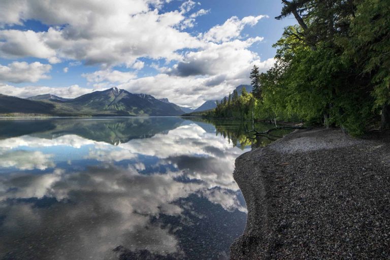
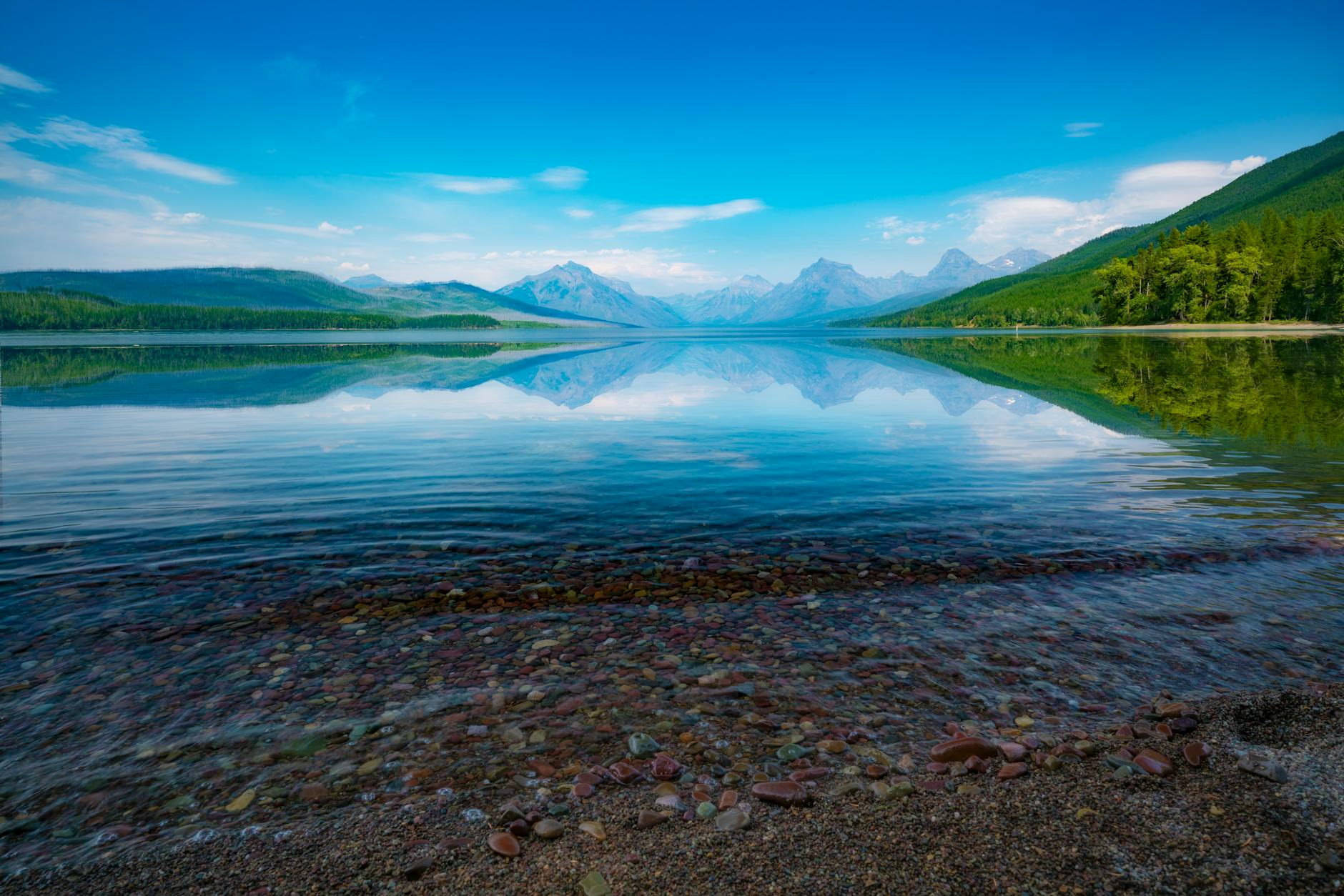
Lake McDonald — West Side
Montana's largest lake; multicolored pebbles on shore, alpenglow peaks reflected in glassy water at sunrise.
- Multicolored pebbles (red, pink, white, gold) line the shoreline at Apgar Village
- Largest lake in park; excellent for sunrise/sunset alpenglow reflection photography
- Accessible shoreline at Apgar Village with multiple viewpoints
- Aurora viewing location in October–March with minimal light pollution
SHORELINE FEATURES
Lake McDonald is Montana's largest freshwater lake. The shoreline at Apgar Village is famous for multicolored pebbles—red, pink, white, and gold stones create a rich foreground for mountain composition. Walk the shore at sunrise to capture alpenglow on surrounding peaks reflected in glassy water.
The lake's size (9 miles long, 1 mile wide) allows for distant peak reflections without crowding. Calm mornings are essential for clear reflections. Spring runoff (May–June) delivers the clearest water; summer algae may slightly reduce color saturation.
LIGHT & SEASONS
Sunrise alpenglow delivers warm orange-pink light on peaks, with cool blue reflections in early morning water. Late afternoon (after 4 PM) provides golden light from the west. Avoid midday overhead light (10 AM–3 PM), which flattens the scene.
Lake McDonald is accessible year-round. Spring (May–June) offers clearest water and extended daylight for sunrise. September–October brings fewer crowds. Winter (October–March) allows for northern lights photography with minimal light pollution on the shores.
COMPOSITION TECHNIQUE
Use multicolored pebbles as a foreground element in wide-angle shots (17–35mm). Position yourself at ground level to emphasize pebble texture against distant peaks. Polarizing filter cuts surface glare and deepens the pebble colors. ND filter enables long-exposure silky-water effects.
Wide-angle ultra-wide lenses (12–24mm digital equivalent) capture the lake's scale and pebble detail simultaneously. Shoot from multiple angles to vary pebble foreground composition. The shoreline near Lake McDonald Lodge offers driftwood and logs for additional compositional interest.
Jackson Glacier Overlook — Going-to-the-Sun Road
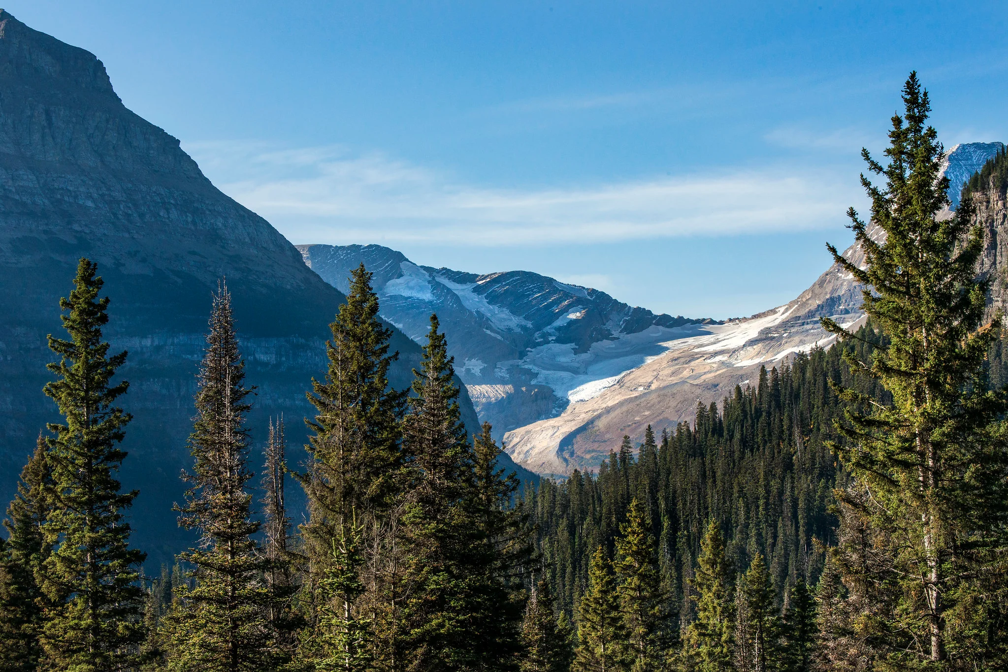
Visible glacier shrinks dramatically; documented climate change from a roadside parking area.
- Best glacier view in park without hiking; direct view from Going-to-the-Sun Road parking
- Jackson Glacier measured 316 acres in 1966, declined to 187 acres by 2015; visible climate change story
- Interpretive signage explains glacier retreat and current dimensions
- Shuttle stop with convenient access (July 1–Sept 7, 2026)
GLACIER ACCESS
Jackson Glacier Overlook provides the best view of a glacier in Glacier National Park without requiring a hike. Located along Going-to-the-Sun Road at 5,400 feet elevation, the glacier is directly visible from the parking area. Interpretive signage documents glacier retreat: Jackson Glacier covered 316 acres in 1966 but had shrunk to 187 acres by 2015—a powerful visual of climate change.
The glacier sits in a rocky cirque with dark cliffs on either side, creating a frame for the white ice. The contrast between white glacier and dark rock makes the glacier stand out even from a distance.
LIGHT & TIMING
Best light: early morning (8–10 AM) when the glacier remains illuminated but shadows begin to define the cirque. Midday light (11 AM–2 PM) flattens the glacier against the rock. Late afternoon light (after 4 PM) casts deep shadows, obscuring glacier detail.
July 1–Sept 7: shuttle service available (tickets on Recreation.gov). Parking fills mid-morning; arrive before 9 AM or use shuttle. June through October, Going-to-the-Sun Road typically open. Early summer (June) may have lingering snow in the cirque, obscuring glacier boundaries.
COMPOSITION
Telephoto lens (100–200mm) compresses distance and isolates the glacier within the rock cirque. Wide-angle (35mm+) captures the full mountainside and surrounding terrain. Polarizing filter reduces haze and increases contrast between glacier and rock.
The glacier's scale is difficult to judge from a photograph; include the cirque walls or sky reference for scale. Early morning clear air provides best visibility and color saturation.
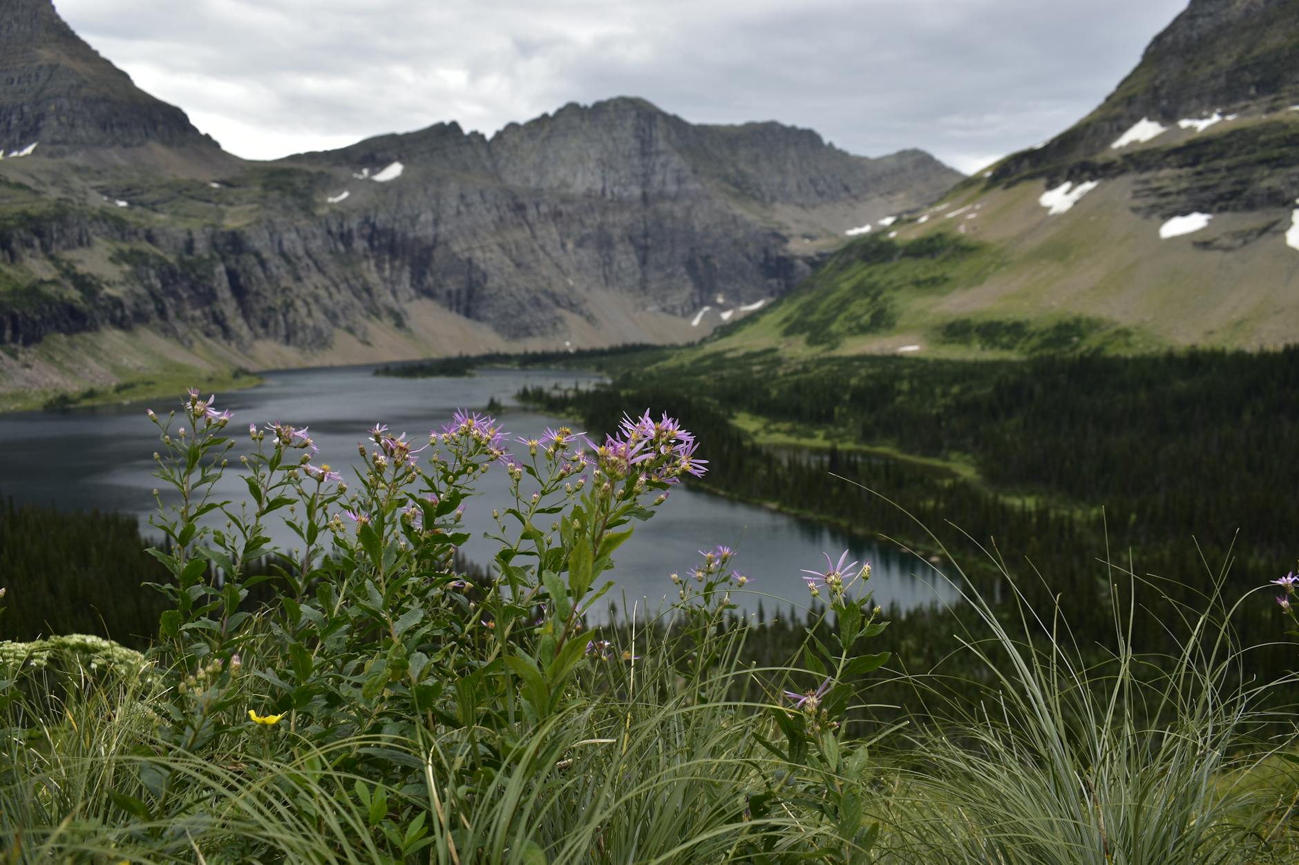
Two Medicine Lake — Two Medicine Valley
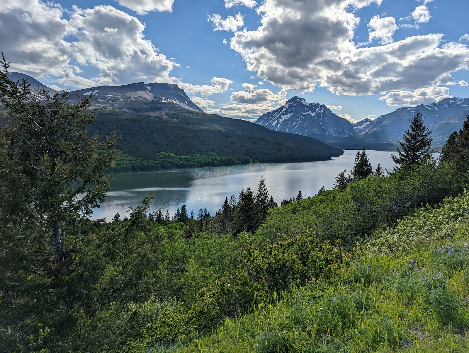
Glacier-carved valley with dramatic peaks; less crowded than Many Glacier, excellent for wildlife and morning light.
- Glacier-carved valley with minimal crowds compared to east side Many Glacier area
- Strong wildlife viewing: moose and beaver activity, especially early morning
- Stunning peak reflections in calm morning water with Sinopah and Rising Wolf Mountains
- Scenic Point trail offers 360-degree alpine vistas (3.9 mi, 2,350 ft elevation gain)
VALLEY & LIGHT
Two Medicine Lake sits in a glacier-carved valley on Glacier's southeast side, accessed via Two Medicine Road from East Glacier. The valley is significantly less crowded than Many Glacier, despite offering comparable mountain scenery. Sinopah Mountain and Rising Wolf Mountain rise dramatically above the glassy lake, creating strong compositional anchors.
Early morning (before 8 AM) delivers calm water, cool alpenglow light on peaks, and active wildlife. The valley's east-west orientation means peak shadows migrate throughout the morning, creating dynamic light conditions. Afternoon light turns golden but crowds often increase.
WILDLIFE & SEASONS
Two Medicine offers strong moose and beaver sightings, particularly in early morning (before 7 AM). Walk the shoreline quietly, scanning the water's edges and marshy inlets. Maintain 75+ feet distance from all wildlife; use telephoto lens (200–400mm) for intimate shots without approaching.
July–August peak season brings more visitors but still fewer than Many Glacier. September brings crisp air and significantly lower crowds. October offers larch golden color on surrounding slopes (early October on east side). All lodging outside park; St. Mary and East Glacier are nearest towns.
TRAIL COMBINATIONS
Running Eagle Falls (0.6 mi, easy, wheelchair-accessible) offers a quick waterfall stop en route. Scenic Point (3.9 mi, 2,350 ft elevation gain) delivers 360-degree alpine vistas. Dawson Pass and Pitamakan Pass offer multiday backpacking options with high alpine photography opportunities.
The Two Medicine Boat Company (Glacier Park Boat Company) operates boat tours on the lake, departing from the boat house. Post-July 1, guided hikes are available (Twin Falls, 1.8 mi) via boat shuttle. Reservations typically book out March–April.
Bowman Lake — North Fork
Remote northwest lake with colorful reflective waters framed by rugged peaks; pristine for landscape photography.
- Remote location accessed via rough dirt road (33 miles from Fish Creek Campground); minimal crowds
- Colorful, reflective waters ideal for landscape and reflection photography
- Short day hike option (1.2 mi) or longer trail to Bowman Lake Head (13.5 mi)
- Pristine dark skies for aurora viewing (October–March) with northern lights
REMOTE ACCESS
Bowman Lake is accessed via the North Fork Road from the west entrance—a rough 33-mile dirt drive through Polebridge to reach the lake. The remoteness provides one of Glacier's most pristine environments with minimal crowds and excellent dark skies. The landscape is dramatically quieter than east-side locations, making it ideal for photographers seeking solitude.
The North Fork Road is unplowed in winter and challenging in spring/fall mud. Summer (July–September) is ideal for vehicle access. Four-wheel-drive or high-clearance vehicle recommended. Plan 1.5 hours of driving time from the west entrance.
WATER & LIGHT
Bowman Lake's water displays unusual coloration—ranging from turquoise to emerald depending on glacial flour concentration and light angle. Sunrise alpenglow on surrounding peaks reflects in the calm morning water, creating warm-cool color contrast. Early morning (before 8 AM) delivers the best reflection quality and light.
The lake is surrounded by rugged peaks with minimal development. Sunrise illuminates east-facing slopes; sunset backlights ridgelines. Weather is highly variable in the remote North Fork; bring layers and prepare for rapid changes.
HIKING & WINTER VIEWING
Short walk option (1.2 mi) reaches the lake shore from the parking area for casual photography. Bowman Lake Head trail extends 13.5 mi with 538 ft elevation gain for backpackers seeking alpine photography. The location is rarely crowded; expect solitude even in July–August.
October–March offers exceptional northern lights viewing (aurora borealis) with minimal light pollution. Winter access requires 4WD and winter tires; the North Fork Road is typically closed or extremely challenging. Backcountry camping available for multi-day wilderness photography expeditions.
Common Questions
What's the best time of year for photography at Glacier National Park?
July–August offers full park access and peak light, but expect 21,000+ daily visitors and crowded parking. September is the best-kept secret: fewer crowds, crisp air, and excellent light. October early month allows larch golden season photography; Going-to-the-Sun Road typically closes mid-October. May–June delivers clear turquoise water and wildflowers at lower elevations but lingering snow may obscure alpine color.
Do I need a permit for landscape or wildlife photography?
Personal photography for non-commercial use requires no permit. Commercial work, groups exceeding 8 people, or photography workshops require a permit ($125 application fee + location/monitoring charges). Drones are entirely prohibited in the park. Contact glac_sup@nps.gov for permit applications (2–4 week processing).
What gear is essential for Glacier photography?
Wide-angle lens (17–35mm) for landscape, telephoto (200–400mm) for wildlife, polarizing filter (essential for water glare and color), tripod for low-light and composition stability, and weather-sealed bag (sudden mountain storms). Spare batteries (cold drains them fast), ND filter for long exposure, and layers (weather changes rapidly from warm sun to cold rain/snow).
Are shuttle reservations required for July–August visits?
Vehicle reservations were retired; they are NOT required in 2026. However, Logan Pass offers 3-hour timed parking July 1–Sept 7 (tickets on Recreation.gov). The free Going-to-the-Sun Road shuttle (July 1–Sept 7 only) eliminates parking stress entirely. June has NO shuttle service—arrive early or use alternate parking.
What wildlife safety distances apply to photography?
Maintain 75+ feet (25 yards) from most wildlife (moose, elk, deer, bears, wolves). Use telephoto lens (200–400mm) instead of approaching animals. Never exit your vehicle to photograph bears. Injuries occur annually from visitors getting too close for photos; the park enforces strict fines for wildlife violations.
Sources & Further Reading
- Wild Goose Island Overlook - NPS
- Logan Pass - NPS
- Jackson Glacier Overlook - NPS
- Photo Tips - Glacier National Park NPS
- Film, Photography, and Sound Recording Permits - NPS
- Wildlife Safety - NPS
- Hiking in Two Medicine - NPS
- Visiting in Winter - NPS
- Night Sky - NPS
- Swiftcurrent Lake - Big Sky Fishing
- Bowman Lake to Kintla Lake - Backpacker