+2 more
1 / 5
Joshua Tree National Park
Last Updated: March 2026
Overview
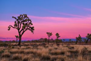
About This Park
Park is open 24/7. Fees apply. Road closures can occur after weather events; verify conditions at the visitor centers. Follow posted rules and park regulations.
Why Visit
Joshua Tree National Park sits at the interface of two deserts, where stark rock formations rise from a landscape of yucca and cactus. Its scale is defined by vast, rugged terrain that compels deliberate pacing: long views, wide skies, and a quiet that invites contemplation. This is a study in contrast—ancient granite stacks juxtaposed with the pliant desert floor—and a reminder of the endurance required to traverse a landscape shaped by wind, fire, and drought. The experience is about navigating a desert environment on human terms: water discipline, early starts, and respect for the climate and terrain.
Highlights
Top Things to Do
Ryan Mountain Trail, Hidden Valley, Barker Dam, Keys View, Arch Rock; Geology Tour Road for a quick view of diverse formations
Family Friendly
Junior Ranger activities available; plan short, stroller-friendly routes near facilities
Accessibility
ADA access varies by trail and facility; visitor centers are accessible; some trails may be uneven or rugged
Photography Tips
Plan for golden hour light; stay clear of traffic lanes when stopping for photos; use pullouts for safety
Best Time to Visit
Avoid extreme heat with shoulder seasons; Oct–May reduce risk of heat-related issues and heavy crowds
Nearby Services
Limited services inside park; towns like Joshua Tree and Twentynine Palms offer groceries, gas, and medical facilities
Tips & Advice
- Buy pass online
- No shuttle requirement
- Arrive early to avoid parking crunch
- Download maps for offline use
- Don’t feed wildlife
Park Strategy
The 3-Day Plan
Day 1: West Entrance loop; Day 2: Explorer routes toward Twentynine Palms; Day 3: Eastern zones and Cholla Garden
Traffic Beater
Enter early; parking fills quickly on weekends; if main lot is full, consider approaching from alternate entrances and using parking pullouts
Where to Sleep
WEST SIDE: Proximity to Joshua Tree Town; more dining and services; EAST SIDE: Higher elevations; quieter, longer drives; base on your priorities
The Timing
October–May busy; weekends and holidays peak; plan weekdays if possible
ℹ️ Data Sources
thepointsguy.com nps.gov visit29.org youtube.com joshuatree.guide islands.com apple.news usgs.gov rainbowtravellife.com recreation.gov sfgate.com Current time information in Riverside County, US. Google Reviews National Park Service YourNPGuide Editorial
Information is compiled from official sources, verified traveler reviews, and editorial research. Learn how YourNPGuide works →