+2 more
1 / 5
Death Valley National Park
Last Updated: March 2026
Overview
About This Park
Death Valley National Park is open year-round, but roads can be closed after storms. A private vehicle entrance is $30 for 7 days; no timed-entry required. Check the Death Valley Status Map before travel.
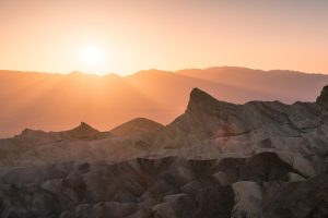
Why Visit
Death Valley is a study in scale and extremes. It spans roughly 3.4 million acres of desertscape, salt flats, canyons, and mountain pass(es) that challenge perception and test planning. The park preserves a record of geological and climatic history, from salt basins to wind-sculpted formations, and it remains a critical landscape for understanding desert ecology and arid-region geology. Visitors come to witness vast landscapes formed by millennia of evaporation, erosion, and dramatic temperature swings. The park supports scientific study and exploration while offering structured avenues to experience its harsh beauty responsibly through designated trails, backcountry permits, and ranger-led programs.
Highlights
Top Things to Do
Badwater Basin, Dante’s View, Zabriskie Point, Mesquite Flat Dunes, Artist’s Drive, Ubehebe Crater, Golden Canyon/Artists Drive region
Family Friendly
Junior Ranger programs and short interpretive walks available; plan for hot days with shaded stops
Accessibility
Limited ADA-accessible facilities; some trails and visitor centers have accommodations
Photography Tips
Sunrise at Dante’s View, sunset at Badwater Rim; avoid stopping on narrow shoulders; use pullouts and designated overlooks
Best Time to Visit
Prefer cooler months to maximize safety and comfort; avoid peak summer heat when possible
Nearby Services
Gas and medical services in Beatty (NV) and nearby gateway towns; larger services in Las Vegas and Bishop
Tips & Advice
- Buy passes online to avoid line
- Shuttles are not mandatory; drive yourself
- Do not drive on unpaved shoulders after storms
- Carry ample water and sun protection
- Check Status Map before heading into backcountry
Park Strategy
The 3-Day Plan
Day 1: CA-190 loop from Furnace Creek; Day 2: Mesquite Flats + Artist’s Drive; Day 3: Panamint Springs region and lookout points
Traffic Beater
CA-190 gates are the main access; arrive early to minimize congestion at popular viewpoints; monitor Status Map for road-specific closures
Where to Sleep
WEST SIDE offers more dining and lodging options with easier access to dunes; EAST SIDE provides higher-elevation views and fewer services; split stays if possible
The Timing
Winter and early spring see higher visitation; summer sees fewer visitors due to extreme heat; plan around popular weekends and holidays
ℹ️ Data Sources
nps.gov deathvalley.com nationalparkstraveler.org reddit.com recreation.gov parksguidance.com happypeoplehike.com herjoliejourney.com bearzoutdoor.com quora.com explore.com usparkpass.com cynhw.com foxla.com umt.edu medium.com usgs.gov Current time information in Inyo County, US. Google Reviews National Park Service YourNPGuide Editorial
Information is compiled from official sources, verified traveler reviews, and editorial research. Learn how YourNPGuide works →