+2 more
1 / 5
Canyonlands National Park
Last Updated: March 2026
Overview
About This Park
Park is open year-round. No timed-entry for general entry; permits required for White Rim Road. Shafer Trail is closed in winter; expect intermittent closures late July–September on Grand View Point Overlook and adjacent road. Main Rule: check current conditions and comply with permit requirements; parking can fill early on weekends March–November.
Why Visit
Canyonlands stretches across three districts—Island in the Sky, Needles, and The Maze—each presenting landscapes carved by rivers and weather on a scale few places match. The park’s vastness demands preparation: long distances between viewpoints, high-clearance access to backcountry routes, and permits for the most remote areas. This is a field laboratory in which geology, hydrology, and ecology unfold in real time, and the contrast between accessible overlooks and remote backcountry forces a disciplined itinerary. Access is shaped by permit systems and seasonal closures, making every visit a study in timing and logistics. The Maze rewards patient navigation; Island in the Sky offers dramatic overlooks with relatively easier access; Needles delivers rugged trails and striking rock formations. Your plan should acknowledge road conditions, water needs, and the pace required to respect this landscape at scale.
Highlights
Top Things to Do
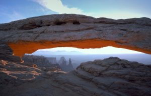
Mesa Arch at sunrise; Grand View Point Overlook; Chesler Park overlook in Needles; explore The Maze with proper planning and permits
Family Friendly
Junior Ranger programs available during peak seasons; choose shorter, paved or near-paved routes for younger visitors
Accessibility
Some overlooks and facilities have accessibility enhancements; many trails and backcountry routes are rugged
Photography Tips
Capture Mesa Arch at dawn from the overlook; keep traffic clear and stay off the road edges; avoid detours that increase risk
Best Time to Visit
Spring and fall offer milder weather and better road access; mornings are best for wildlife viewing
Nearby Services
Moab provides gas, medical services, groceries; on-site services within park are limited
Tips & Advice
- Book passes and backcountry permits online via Recreation.gov
- White Rim Road requires a permit; 4x4 required
- Parking can fill early; arrive before dawn
- Bring water; cellular service is unreliable
- Use designated pullouts for wildlife watching
Park Strategy
The 3-Day Plan
Day 1: Island in the Sky loop; Day 2: Needles District exploration; Day 3: Maze backcountry planning with permit in hand
Traffic Beater
Parking fills on weekends; plan for early arrival; check road statuses for Shafer Trail and Grand View Point corridors
Where to Sleep
WEST SIDE (Island in the Sky): easier access, more water, more developed facilities; EAST SIDE (Needles): remote, more rugged, less dining; plan accordingly
The Timing
Parking pressure peaks on weekends and holidays from March through November; September tends to be quieter
ℹ️ Data Sources
discovermoab.com nps.gov utah.com entrance-fee.com moabtimes.com recreation.gov youtube.com reddit.com latimes.com noahlangphotography.com wereintherockies.com cnha.org wikipedia.org ksl.com townlift.com idyllwildtowncrier.com Current time information in Wayne County, US. gastateparks.org mdpi.com forbes.com Google Reviews National Park Service YourNPGuide Editorial
Information is compiled from official sources, verified traveler reviews, and editorial research. Learn how YourNPGuide works →