Highway 2 Scenic Corridor: Glacier’s Southern Boundary Drive
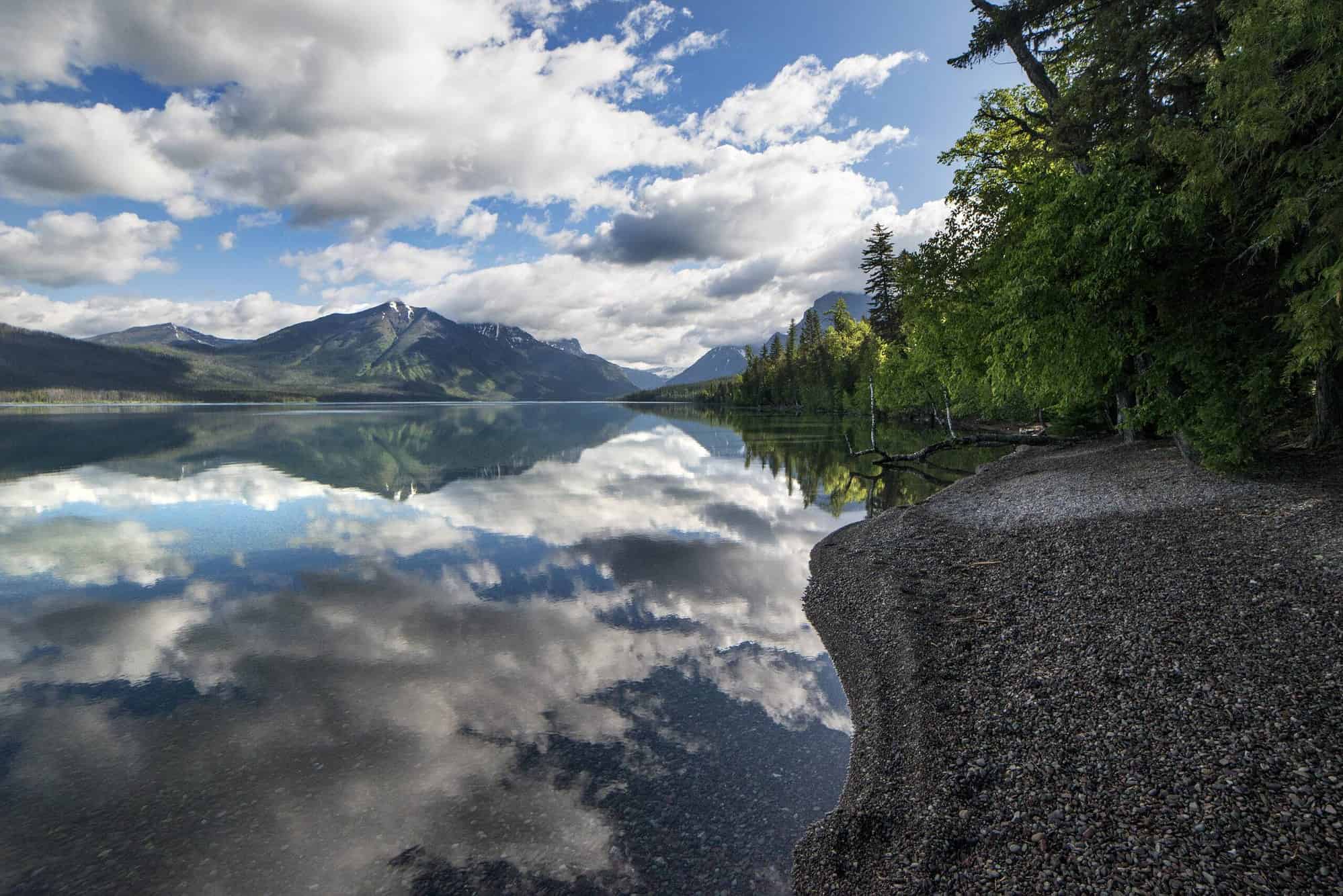
Highway 2 runs 56 miles along the southern boundary of Glacier National Park, connecting West Glacier to East Glacier Park village through granite canyons, dense wilderness, and one of the lowest Continental Divide crossings in North America. Unlike the famous Going-to-the-Sun Road — which closes to vehicles October through late spring — Highway 2 stays open year-round, making it a critical alternate route and a stunning destination drive in its own right.
Plan about 2 hours end-to-end at a 40–50 mph speed limit, but a full day if you stop for hiking, rafting, wildlife viewing, or the mountain goat spectacle at Goat Lick Overlook. Entrance to the park is not required to drive Highway 2 itself, though stops inside the park boundary cost $35 per vehicle (7-day pass) per NPS.gov.
- Highway 2 spans 56 miles from West Glacier to East Glacier Park along Glacier’s southern boundary — open year-round, unlike Going-to-the-Sun Road.
- Goat Lick Overlook near Essex is free to visit; best mountain goat viewing runs late May through mid-July, dawn and dusk.
- Marias Pass at 5,213 ft is the lowest Continental Divide crossing between Canada and central New Mexico — no park pass required to stop here.
- The Middle Fork of the Flathead River runs alongside the highway and offers Class II–III whitewater rafting from Essex to West Glacier.
- Scalplock Lookout Trail (3.2 miles one-way, 3,000 ft gain) starts from the Walton Ranger Station on Highway 2 with panoramic fire-lookout views.
- Two Medicine Valley — just north of East Glacier via Hwy 49 — is the quieter, less-crowded eastern entry point to the park.
- Park entrance fee: $35/vehicle, $30/motorcycle, $20/hiker or cyclist (7-day pass). Non-U.S. residents pay an additional $100 per person age 16+.
Route Overview & When to Drive
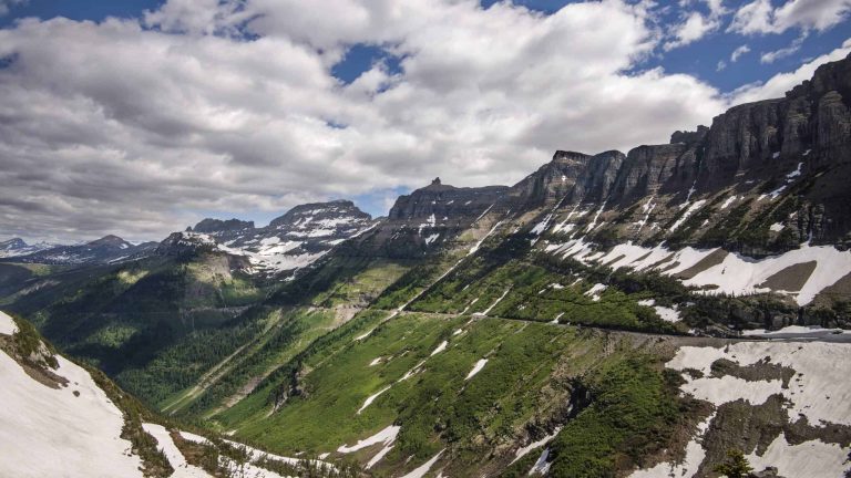
Highway 2 (US Route 2) traces the southern border of Glacier National Park through the Lewis Range for 56 miles, from West Glacier (elevation 3,154 ft) over Marias Pass (5,213 ft) to East Glacier Park village. The route follows the Middle Fork of the Flathead River through granite canyon country before climbing to the Continental Divide and descending into the Two Medicine foothills.
Because it never enters the interior of the park, Highway 2 stays plowed and passable year-round — a major advantage in shoulder and winter months when Going-to-the-Sun Road is closed. That said, driving conditions between November and March require winter tires, and mountain passes can receive snow at any time.
| Season | Road Conditions | Best Highlights |
|---|---|---|
| May–July | Clear; occasional late-spring snow at pass | Goat Lick peak season (dozens of goats), wildflowers at Marias Pass |
| August–September | Excellent; warm and dry | Full hiking access, rafting, fall foliage begins in September |
| October–November | Good with rain/frost; mountain snow possible | Elk rut, fall color, far fewer crowds |
| December–April | Passable with winter tires; some closures at pass | Izaak Walton Inn cross-country skiing, wolf and moose sightings |
Starting at West Glacier
West Glacier sits at the junction of Highway 2 and the Going-to-the-Sun Road entrance, making it the natural western anchor for this drive. The small community holds gas stations, grocery options, gear shops, and multiple raft-trip outfitters — stock up here before heading east, since services thin out quickly once you enter the canyon corridor.
If you have a park pass, West Glacier is also your gateway to Lake McDonald Lodge, the Apgar Visitor Center, and the iconic Going-to-the-Sun Road when it is open to vehicles (typically late June through mid-October, per NPS.gov). Drivers combining both routes in one day can tackle Highway 2 in the morning — stopping at Marias Pass and Goat Lick — then return via Going-to-the-Sun Road in the afternoon.
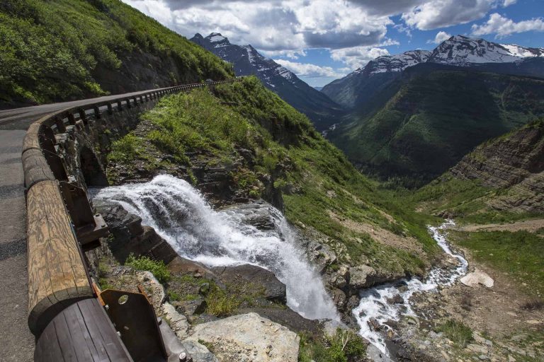
Middle Fork of the Flathead River
From West Glacier eastward, Highway 2 rarely strays far from the banks of the Middle Fork of the Flathead River, which forms the legal southern boundary of the park. The river flows from deep inside the Great Bear Wilderness before joining Highway 2 near Essex, collecting additional tributaries until it merges with the North Fork near West Glacier to form the main Flathead River.
Some links below are affiliate links.
The most popular whitewater stretch runs from Essex to West Glacier — a section loaded with Class II and III rapids that several local outfitters run from late May through September. Scenic float trips (gentler, no whitewater) are also available and work well for families or those who prefer a quieter river experience. If you prefer to stay dry, numerous pullouts along the highway let you watch bright-colored rafts bounce through the named rapids below the road.
Fly-fishing is another draw. The Middle Fork is a federally designated Wild and Scenic River, and its cold, clear waters hold westslope cutthroat trout. Walk-and-wade access is possible at multiple points along the highway, though check current fishing regulations at Montana FWP before casting.
Essex & Goat Lick Overlook
The tiny community of Essex, located approximately 26 miles east of West Glacier, is the midpoint of the Highway 2 corridor and home to two highlights: the Goat Lick Overlook and the historic Izaak Walton Inn.
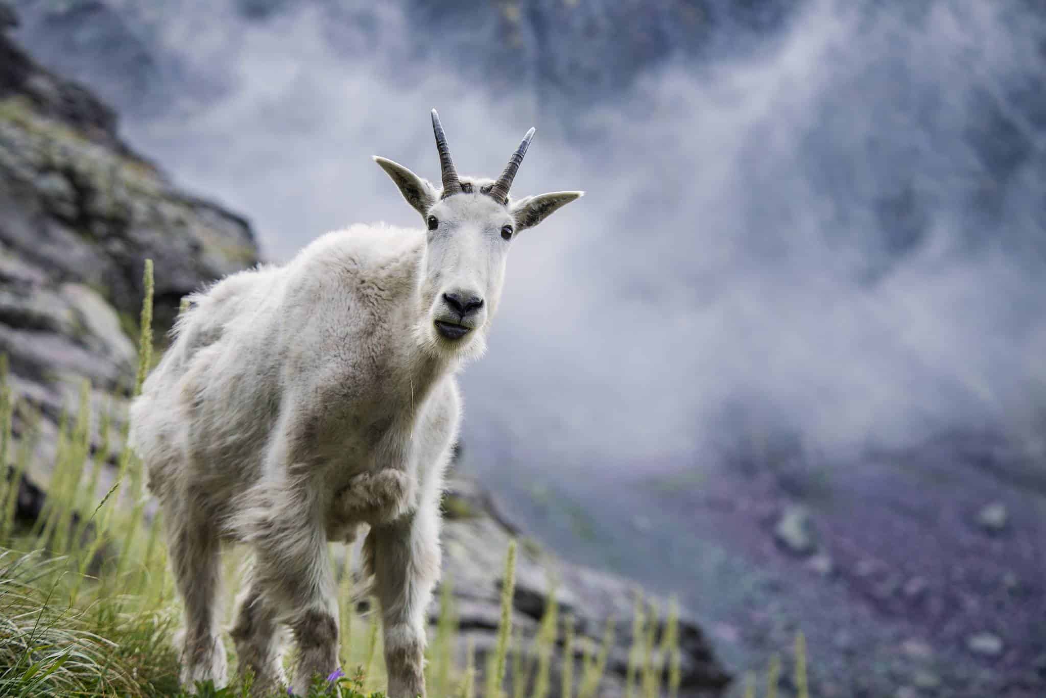

The Goat Lick Overlook sits about 2 miles southeast of the Walton Ranger Station and is one of the most reliable mountain-goat viewing sites in the American West. A short accessible paved path leads from the parking area to an observation platform overlooking the Middle Fork and an exposed cliff face of Roosevelt Fault rock rich in gypsum, kieserite, and sulfates. Mountain goats descend to lick these minerals — most intensely April through August, with peak crowds of dozens of animals in late June and early July, per NPS.gov.
Goats follow crepuscular schedules — activity peaks at dawn and dusk. Arriving midday in July you may see only a handful; arriving at 6 AM or 7 PM in the same week you might find 30 or more. No fee is required. Dogs must remain leashed at all overlook areas along Highway 2.
The Izaak Walton Inn at Essex was built in 1939 by the Great Northern Railway to house the snowplow crews responsible for keeping this critical railroad pass open in winter. Today it operates as a year-round lodge and is especially popular with railroad enthusiasts, as active BNSF freight trains still rumble past the front door daily. In winter, the inn serves as a cross-country ski hub with groomed track connecting to backcountry routes in the surrounding wilderness.
Scalplock Lookout Trail
For hikers who want panoramic views from the Highway 2 corridor without driving into the park interior, the Scalplock Lookout Trail begins at the Walton Ranger Station boundary trailhead — directly off Highway 2 near Essex. The first section follows the Middle Fork before turning steeply upward through dense forest.
| Detail | Data |
|---|---|
| Distance (round-trip) | 6.4 miles |
| Elevation gain | ~3,000 ft |
| Difficulty | Strenuous |
| Summit elevation | ~6,926 ft |
| Trailhead | Walton Ranger Station, Hwy 2 near Essex |
| Water on trail | None above river section — carry all water |
| Best season | July–October (snow clears late) |

The payoff at 3.2 miles is the historic Scalplock Fire Lookout, staffed seasonally by the National Park Service. Views extend across Glacier’s southern reaches, over the Bob Marshall Wilderness to the south, and east toward the Rocky Mountain Front. On a clear day the summit is one of the most dramatic vantage points accessible directly from Highway 2 without paying a park entrance fee.
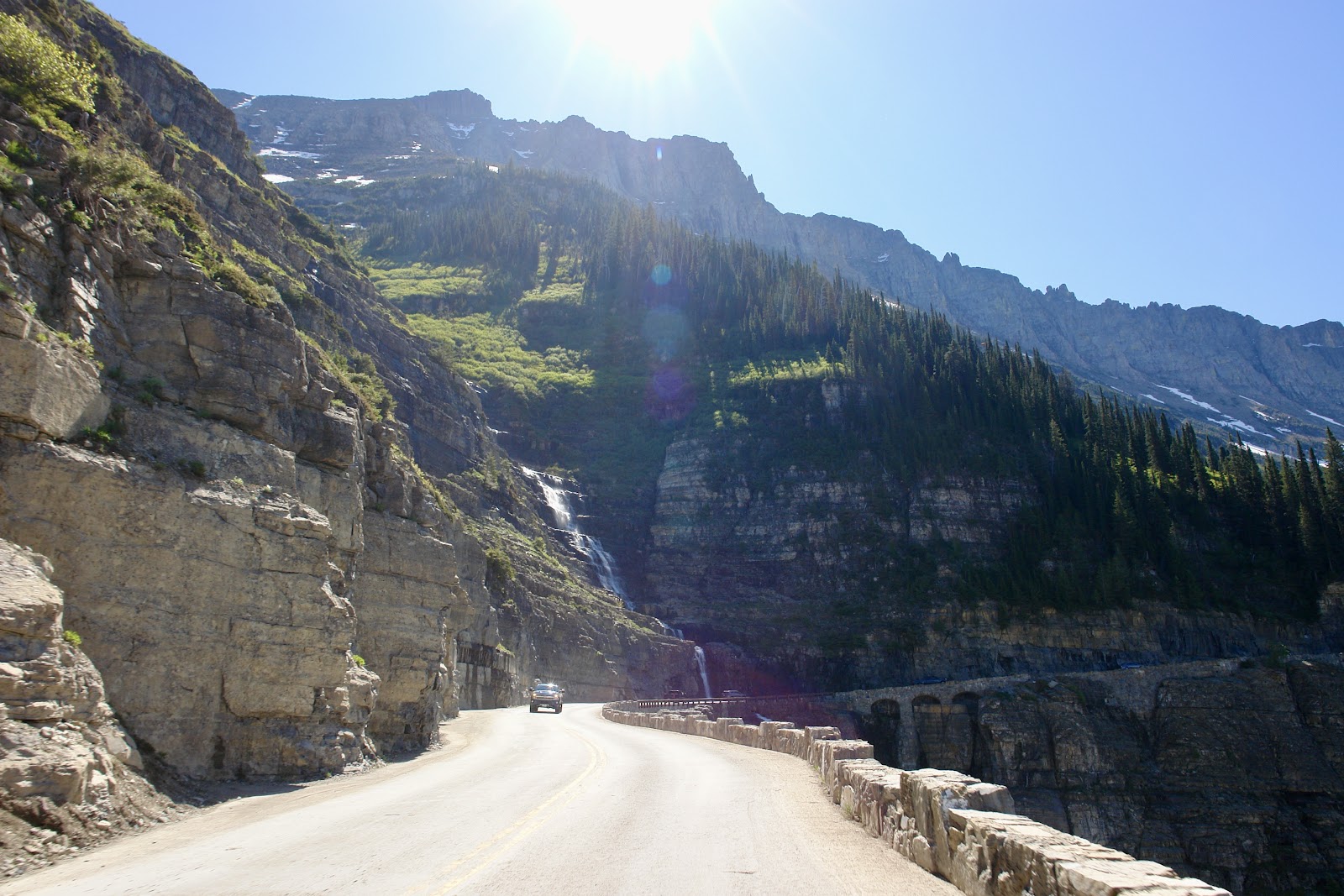
Marias Pass & the Continental Divide
About 44 miles east of West Glacier — or 12 miles west of East Glacier — Highway 2 crests the Continental Divide at Marias Pass at an elevation of 5,213 feet. It is the lowest divide crossing between Canada and central New Mexico and the northernmost vehicle-accessible pass in the continental United States that stays open year-round.
Marias Pass is steeped in exploration and railway history. Meriwether Lewis named the nearby Marias River after his cousin Maria Wood during the 1805 Corps of Discovery expedition, and the pass carries that name. Engineer John Frank Stevens finally charted the route in December 1889 for the Great Northern Railway; the first rails crossed in September 1891 and the initial train ran in 1893. Today BNSF freight trains still roll through daily, and a large bronze statue of Stevens stands at the summit parking area alongside a Theodore Roosevelt Memorial.
No park pass is required at Marias Pass — the summit lies within Lewis and Clark National Forest, outside Glacier’s fee boundary. Meadows around the pass bloom with beargrass and wildflowers in July, and elk and deer are commonly seen at dawn and dusk. The pass sits at 5,213 ft so temperatures can be 10–15°F cooler than West Glacier even in summer; bring a layer.
East Glacier Park & Two Medicine Valley
The eastern end of the Highway 2 corridor is East Glacier Park village, a small community with lodging, dining, and the historic Glacier Park Lodge — built in 1913 by the Great Northern Railway from Douglas fir timbers. Gas, groceries, and an Amtrak station (Empire Builder line) make East Glacier a practical multi-day base.
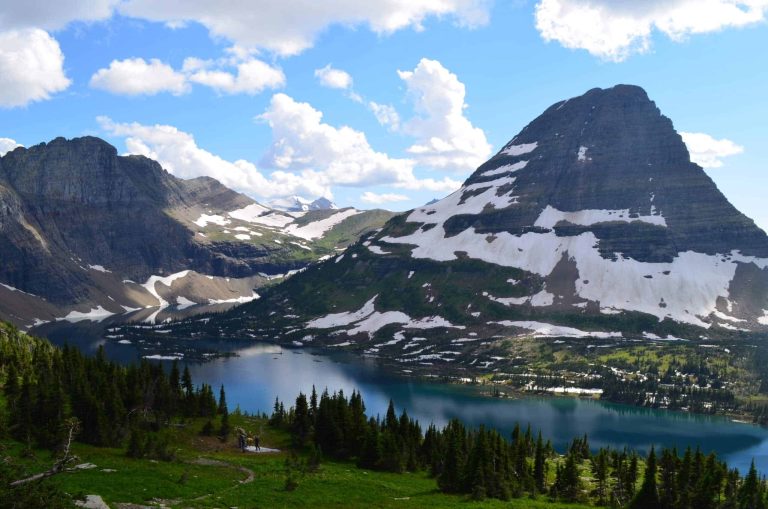
Just north of East Glacier, Two Medicine Valley is reached by taking Highway 49 north for roughly 4 miles, then turning onto Two Medicine Road (approximately 8 miles, paved). Two Medicine is one of the park’s most underrated areas — a glacier-carved valley with deep turquoise lakes, waterfalls, and over 30 miles of trails, all without the permit queues and traffic of Going-to-the-Sun Road. The $35/vehicle entrance fee applies at the Two Medicine station. The road is open roughly late May through mid-October; snow typically closes it from mid-October to mid-May, per NPS.gov.
Popular Two Medicine hikes include the Upper Two Medicine Lake Trail (9.4 miles round-trip, relatively gentle with modest elevation gain) and the short walk to Running Eagle Falls (less than 1 mile, accessible to all fitness levels). Glacier Park Boats operates guided tours on Two Medicine Lake from late spring through early fall.
Practical Tips & Quick-Reference Stops
Highway 2 is a straightforward 2-lane paved highway, but a few logistics matter for a smooth drive:
| Stop | Mile (from West Glacier) | Cost | Best For |
|---|---|---|---|
| West Glacier | 0 | Free (highway) | Gas, food, raft bookings, park entry |
| River pullouts | 10–26 | Free | Raft watching, wildlife, fishing |
| Essex / Izaak Walton Inn | ~26 | Free to visit; lodging varies | Train watching, ski/hike base, dining |
| Goat Lick Overlook | ~28 | Free | Mountain goat viewing (best late May–July) |
| Scalplock Lookout TH | ~26 | Free (no park pass needed) | Strenuous summit hike with fire lookout |
| Marias Pass | ~44 | Free (National Forest land) | Continental Divide, history, wildflowers |
| East Glacier Park | 56 | Free (village) | Lodging, dining, Amtrak, trailheads |
| Two Medicine Valley | 56 + 12 via Hwy 49 | $35/vehicle park pass | Lakes, waterfalls, uncrowded hiking |
Gas: Fill up in West Glacier or East Glacier. There is no gas station in Essex or anywhere along the 56-mile corridor.
Cell service: Spotty through canyon sections between West Glacier and Essex. Download offline maps before departing.
RVs and trailers: Highway 2 has no vehicle length or width restrictions and is the recommended alternate when RVs are excluded from Going-to-the-Sun Road during peak season (vehicles over 21 ft are restricted on certain GTTS sections).
America the Beautiful Pass: Covers the $35/vehicle entry at Two Medicine and West Glacier entrances. Annual passes are $80 and available at any park entrance station or store.usgs.gov.
Frequently Asked Questions
Do I need a Glacier National Park pass to drive Highway 2?
When is the best time to see mountain goats at Goat Lick Overlook?
Is Highway 2 open in winter?
How do I book a raft trip on the Middle Fork of the Flathead River?
What is the elevation at Marias Pass and why does it matter?
How We Researched This Guide
- NPS.gov — Glacier National Park fees, directions, mountain goat information, Two Medicine hiking, and GTTS Road seasonal schedule
- Glacier Country Tourism (glaciermt.com) — Highway 2 corridor highlights and scenic stop descriptions
- Wikipedia and historical records — Marias Pass elevation, Great Northern Railway history, John Frank Stevens
- AllTrails — Scalplock Lookout trail distance, elevation gain, and user reports
- Crown of the Continent Geotourism — Goat Lick geological context and Izaak Walton Inn history
- Montana FWP (fwp.mt.gov) — Middle Fork fishing regulations and Wild and Scenic designation
- gorafting.com and glacierguides.com — Middle Fork rafting section details
Entrance fees and road opening/closing dates change annually. Verify current conditions at nps.gov/glac before visiting. Raft outfitter availability and Two Medicine boat tours operate on seasonal schedules — book directly with providers for current pricing and departure times.
Ready to plan your Highway 2 road trip along Glacier’s southern boundary? Check current road conditions, entrance fees, and seasonal closures…