Skip to content
YourNPGuide.

Pardon the construction. We are in the middle of a major rebuild of YourNPGuide to make planning your trip easier. Some pages may look different, move, or change between visits while the work is under way.

a mountain glacier with a lake and mountains behind

MONTANA / YOUR GLACIER TRIP STARTS HERE

Glacier
National Park

Glacier-carved peaks, turquoise lakes and the most scenic mountain road in the country, on the Montana side of the Canadian border. Pick your month and days and we will help you plan the rest.

From our visits, August 2024 and September 2025 No photo prepares you for the scale. The sheer size of everything is the biggest shock of a first visit.

Your Glacier trip

Change these and the plan, the warnings and the lodging advice below follow.

See your 3-day July plan

Choices stay in this browser only. No account.

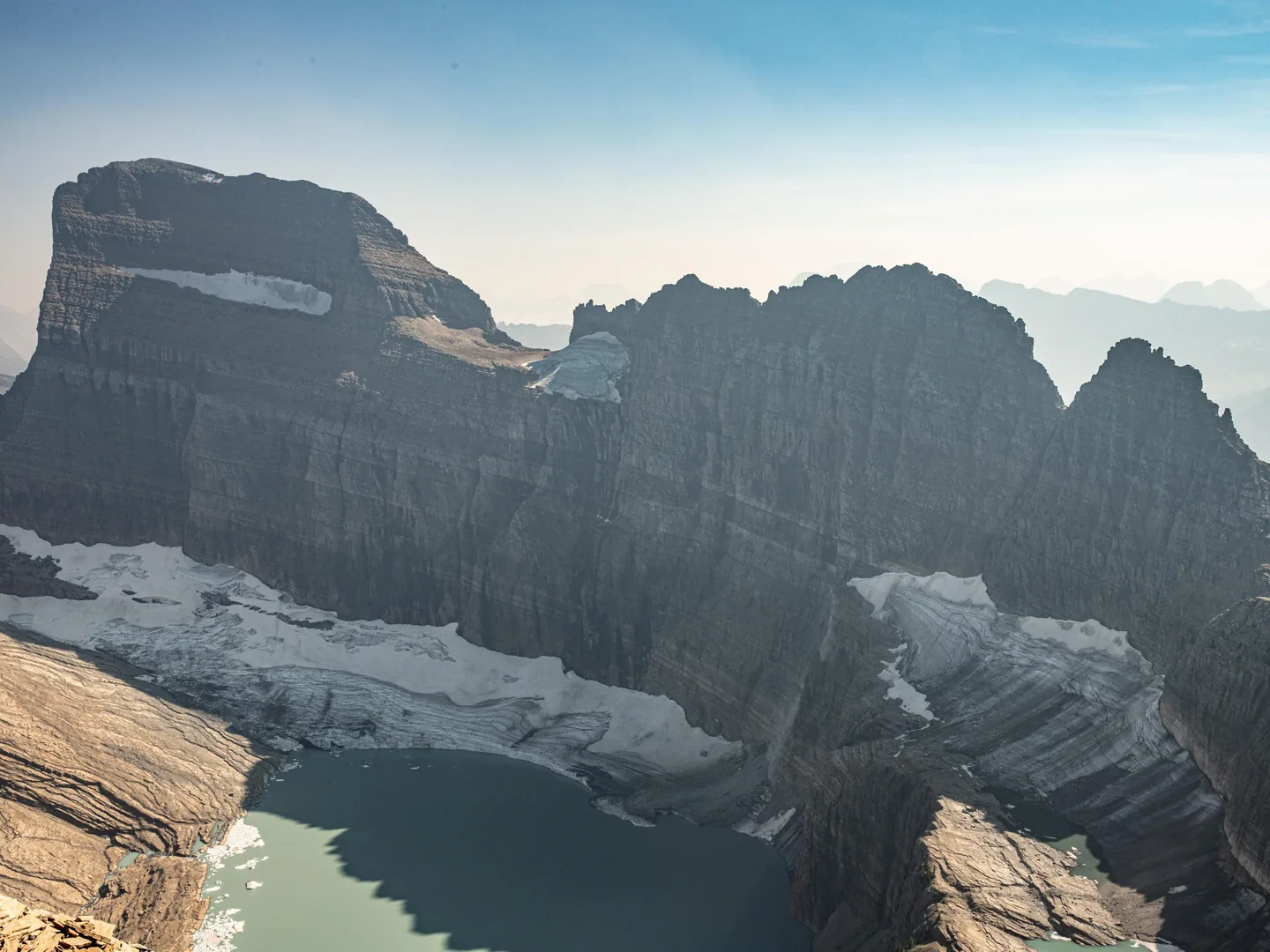
Grinnell Glacier from Upper Grinnell Ridge · September 2025 photographNPS photo

BEFORE YOU GO · VERIFIED AGAINST NPS

Vehicle reservation
Not required in 2026
Entrance fees still apply · verified Sep 8
Logan Pass parking
3-hour limit
July 1 to September 7, enforced 24 hours a day · verified Sep 8
Going-to-the-Sun Road
Fully open since June 22
Alpine section usually late June to mid-October; closes when snow arrives · verified Sep 1
Entrance fee
$35 per vehicle
7 days; the park does not accept cash · verified Sep 8

YOUR ITINERARY, DRAFTED FOR YOU

This could be your 3 days in July.

Open the full 3-day itinerary ↗

Use separate days for the west side, the road and an east-side area. Group outings by location instead of crossing the park repeatedly.

Jagged peaks rise out of a forested valley and an empty road curves off into the distance.

Day 1 · Across the mountains

Let Going-to-the-Sun Road be the day

Start from your arrival side, pick a few stops, and decide before you leave where you will finish. Hidden Lake Overlook if you can reach Logan Pass by late morning.

Watch Logan Pass parking is limited to 3 hours in summer. Start early or ride the ticketed shuttle.

Day detail in the itinerary ↗
a mountain glacier with a lake and mountains behind

Day 2 · East side, own entrance

Give Many Glacier its own day

Come for the lake-and-mountain setting and choose a hike to match your ability. Seeing the area does not require the Grinnell Glacier hike.

Fits because A separate entrance near Babb, so it never fits as a detour on a road day.

Day detail in the itinerary ↗
Jagged peaks rise out of a forested valley and an empty road curves off into the distance.

Day 3 · East side

St. Mary: a walk, a viewpoint and time to breathe

St. Mary and Virginia Falls in the morning, Sun Point and the Rising Sun rock in the afternoon. Allow real time if you are returning west.

Fits because Pairs naturally with the end of a road day, or stands alone if you are based in St. Mary.

Day detail in the itinerary ↗
a mountain glacier with a lake and mountains behind

Day 4 · East side, own entrance

Two Medicine: a different valley, not a detour

Running Eagle Falls, the lake boat, Aster Park if you want a climb. Check the 2026 construction notice before you drive out.

Watch One valley, one day. Compare it with Many Glacier before committing to both.

Day detail in the itinerary ↗
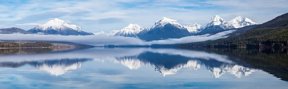
Fog over Lake McDonald beneath forested mountains

Day 5 · West side

Slow down beside Lake McDonald

Apgar gives you a lakeside introduction on the west side. Trail of the Cedars and Avalanche Lake are right up the road, and a boat rental turns an afternoon into the day.

Fits because Keeps an arrival afternoon from becoming a long transfer, and it is the natural rest day on a longer trip.

Day detail in the itinerary ↗
Fog over Lake McDonald beneath forested mountains

Day 6 · North Fork

Bowman Lake and Polebridge, or keep it local

Gravel road in, no services, the quiet corner. Give it the whole day and fill the tank before you leave the highway.

Watch NPS says to allow all day. Prepare offline; there is no signal.

Day detail in the itinerary ↗
Jagged peaks rise out of a forested valley and an empty road curves off into the distance.

Day 7 · Flex day

Leave room for the trip you actually had

Weather, a slower start, a repeat of the place that surprised you, or an afternoon in town. Protect your departure time.

Watch More time does not guarantee trail or road access; a seven-day trip needs a day that is not a plan.

Day detail in the itinerary ↗

From our visits, August 2024 and September 2025

Three days done right: day one Going-to-the-Sun Road with Hidden Lake and St. Mary Falls; day two Avalanche Lake, Trail of the Cedars and a Lake McDonald boat rental; day three a new corner of the park. Many Glacier earns it.

The best planning move is picking your trails before you arrive. The trail list is the trip.

The park wakes up on the water in the morning, moves to the alpine at midday, and goes quiet by sunset.

FIVE AREAS, FAR APART

Areas of the park

Open the official park map

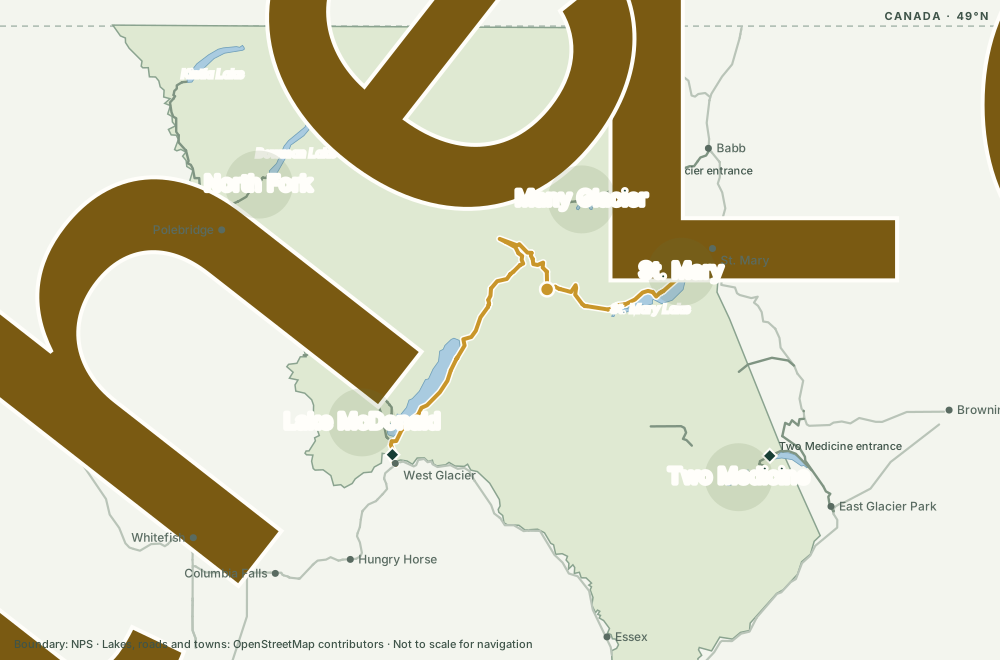
Glacier is big and its areas are far apart, with separate entrances. Pick the ones that matter most to you and build your days around them.

Map of Glacier National Park areas: North Fork, Lake McDonald, St. Mary, Many Glacier and Two Medicine, with Going-to-the-Sun Road over Logan Pass and the entrance stations

Boundary from the National Park Service; lakes, roads and towns from OpenStreetMap. Orientation only, not a navigation map. Every area label matches a card below.

Jagged peaks rise out of a forested valley and an empty road curves off into the distance.
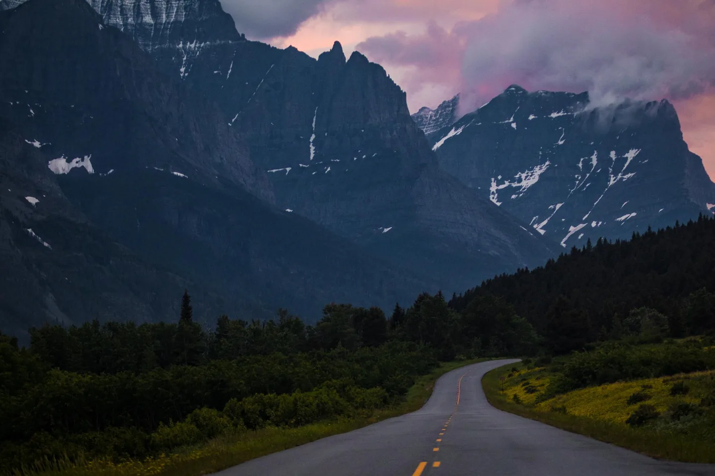
Going-to-the-Sun Road, St. Mary side · NPS photo

THE DRIVE EVERYONE COMES FOR

Going-to-the-Sun Road

About fifty miles from Lake McDonald over Logan Pass to St. Mary, with pullouts, waterfalls and the Hidden Lake trail along the way. Give it a full day and pick a few stops rather than trying to see everything.

  • There is no fuel on Going-to-the-Sun Road: roughly 33 miles with no gas stations between the service areas at either end. NPS ↗
  • Going-to-the-Sun Road vehicles are limited to 21 feet in length, 8 feet in width and 10 feet in height. NPS ↗
  • The 2026 Logan Pass shuttle is a ticketed express service running July 1 through September 7; tickets cost $1 per person on Recreation.gov and are required for every rider age 2 and up. NPS ↗

From our visits, August 2024 and September 2025

The road takes about 3 to 4 hours with pullouts only.

About 8 hours once you add hikes.

Drive west to east for uninterrupted views: most pullouts are on the south side.

Logan Pass parking can take about 20 minutes of circling around noon.

The road is usually quiet around 7 a.m.

Road guide: stops, shuttle and parking

North Fork

West

Polebridge, Bowman and Kintla lakes. Gravel roads, no services, the quiet corner. A different trip from the rest of the park.

Base
Polebridge or Columbia Falls
Known for
Bowman Lake shore
Fits
A full day, drive included
  • NPS says to allow all day to drive to and from Kintla and Bowman Lakes.
  • The North Fork is reached only by private vehicle on unpaved roads.
  • The only services are outside the park in Polebridge.

Our take Fill the gas tank at every opportunity, and always before entering the park.

Polebridge and the North Fork →

Lake McDonald

West

Apgar, the lake and the historic lodge. The west entrance and the easiest first afternoon in the park.

Base
Apgar or West Glacier
Known for
Avalanche Lake, Trail of the Cedars
Fits
Arrival day or a half day
  • About 90 minutes from Apgar to Logan Pass

Our take The west side around Lake McDonald is the best first-timer base: easiest access and the most sights per day, though not the park's most unique corners.

Our take Lake McDonald sunset beats sunrise. Evening water sits calmer; morning wind chops the reflections apart.

Lake McDonald →

St. Mary

East

The east entrance, Rising Sun and St. Mary Lake, where the mountains meet the prairie.

Base
St. Mary
Known for
St. Mary and Virginia Falls, Sun Point
Fits
Half day, or the end of a road day
  • About 60 minutes from St. Mary to Logan Pass

Our take From the St. Mary side, the mountain backdrop over the lake and Wild Goose Island is far more dramatic than anything on the west side.

Our take Parking on the St. Mary and Rising Sun side is plentiful compared to the west-side lots.

Saint Mary Lake →

Many Glacier

Northeast

The hiking heart of the park, with its own entrance near Babb. Glaciers, lakes and the big historic hotel.

Base
Many Glacier, Babb or St. Mary
Known for
Grinnell Glacier, Iceberg Lake
Fits
Its own full day

Our take Many Glacier is cozier, quieter and more quaint than the west side. Absolutely worth the trip, and the road there is not as rough as its reputation.

Our take Swiftcurrent Lake is the most picturesque shoreline in the park, the one that pulls you back.

Many Glacier Road guide →

Two Medicine

Southeast

A lake surrounded by peaks near East Glacier Park, with its own entrance and far fewer people.

Base
East Glacier Park
Known for
Running Eagle Falls, the lake boat
Fits
A full day; compare with Many Glacier
  • Running Eagle Falls trail is wheelchair accessible.

Our take Gas and supplies on the Blackfeet Nation side around Browning and East Glacier cost noticeably more. Fuel up west of the park.

Many Glacier vs Two Medicine →

SLEEP CLOSER TO YOUR PLANS

Where will you sleep?

In-park rooms sell out months ahead and decide the rest of your trip. Mark a must-do area above and we will suggest a side; otherwise start from wherever you arrive.

Lodging in the park

Hike-in only: Sperry Chalet and Granite Park Chalet. Reservations, not walk-ups.

Camping in the park

Every campground here is dry camping: no electric, water or sewer hookups. Vehicles over 21 feet long or 8 feet wide are not allowed on the alpine section of Going-to-the-Sun Road, so a big rig on the west side stays below Avalanche and on the east side stays below Sun Point.

Reserve first. Most in-park lodging and campgrounds require reservations, and the lodges open their booking window about a year ahead. Decide this before the itinerary.

From our visits, August 2024 and September 2025

Apgar campground books out the moment dates open. Be ready the second reservations go live; sites vanish fast.

Apgar campground runs around twenty dollars a night, the budget base for the west side.

THE TRAIL LIST IS THE TRIP

Trails, by area

Browse trails

Every trail below is a Glacier trail guide on this site. "Short walk", "half day" and "full day" are our commitment labels, not official ratings. Check current trail status before you go; bear closures are common at Many Glacier.

Lake McDonald West

Trail of the CedarsBoardwalk loop through the cedars; wheelchair accessible; no shuttle stop in 2026
Short walk
Avalanche LakeNearly flat lake walk from the Cedars loop; swim if you dare
Half day
Johns Lake LoopQuiet forest loop near the lodge
Short walk
Apgar LookoutBig climb, big view of the lake
Full day

Our take Avalanche Lake is about 4.5 miles round trip and nearly flat; a quick group finishes in roughly an hour and a half.

Our take Trail of the Cedars is underrated: a Pacific-Northwest-feeling cedar grove tucked into a Rocky Mountain valley.

Our take A black bear can turn up right on the Avalanche Lake trail. Carry spray.

Along the road Logan Pass

Hidden Lake OverlookBoardwalk from Logan Pass; goats near the top; 3-hour parking in summer
Half day
Highline TrailAlong the Garden Wall to The Loop; shuttle back
Full day
Siyeh PassOne of the high ones; snow lingers into July
Full day

Our take Hidden Lake Overlook takes a quick group about 45 minutes to an hour round trip; the altitude slows people more than the boardwalk suggests.

Our take Mountain goats hang out near the end of the Hidden Lake boardwalk.

St. Mary East

Saint Mary FallsSt. Mary and Virginia Falls as one hike; Baring Falls on the way
Half day

Our take The St. Mary Falls hike was the best 30-minute experience of the trip.

Our take Virginia Falls is underwhelming in August, though its small upstream stream is interesting to follow.

Our take The St. Mary side still carries standing fire-killed trees, and in high wind they drop across trails without warning.

Many Glacier Northeast

Grinnell GlacierThe glacier hike; boat shortcut available
Full day
Iceberg PtarmiganGentle grade to a lake with icebergs into summer
Full day
Redrock FallsFlat, along the lakes to the falls
Half day
Apikuni FallsShort and steep to a waterfall
Short walk
Swiftcurrent LakeLakeside loop from the hotel
Short walk

Our take When the hotel and Swiftcurrent lots fill, overflow parking adds real mileage to your hike.

Our take Cracker Lake's vivid blue water is the story you tell first, and the coldest swim in the park.

Two Medicine Southeast

Running Eagle Falls NatureAccessible nature trail to the falls
Short walk
Aster FallsThe short version of the Aster Park walk
Short walk
Aster Park OverlookPast Aster Falls to the overlook
Half day

North Fork West

Bowman Lake CampgroundBowman Lake shore from the campground
Any length
Kintla LakeKintla Lake: remote, long gravel drive
Any length

From our visits, August 2024 and September 2025

Posted hike times run generous; a steady group finishes most trails in about two-thirds of the sign estimate.

Bear spray from the Walmart in the gateway towns runs about forty dollars.

PREFER SOMEONE ELSE TO DRIVE, ROW OR LEAD?

Guided days from West Glacier

Browse activities

Booked through Viator, run by local outfitters out of West Glacier. Ratings and review counts come from Viator and refresh with our product sync; check dates and inclusions on the booking page.

Viator links are affiliate links; we may earn a commission at no extra cost to you. Free, independent and direct-operator options are in each area guide.

PICK THE PLACES. MAKE IT YOUR TRIP.

Build the rest of your Glacier trip.

Somewhere to sleep. A good meal. A town worth exploring. Find actual places here; use the guides below when you need help deciding.

What would you like to find?

Browse a category → open a place → build your shortlist.

Read the individual place guide, then use its planning controls to save an idea or add a visit. Your saved choices stay in My trip in this browser.

A DIFFERENT KIND OF REFERENCE

Notes from our August and September visits.

Everything marked "from our visit" on this page comes from YourNPGuide's own Glacier trips: an Apgar base in August 2024 with days on both sides, and the road end to end again in September 2025. These are dated observations, not today's conditions or promises about your trip.

Leave room for Trail of the Cedars

The site’s August 2024 visit notes describe a lush cedar forest that felt unexpectedly different from the surrounding mountain scenery. It was worth noticing, not just passing through on the way to another lake.

Think about the walk, not only the final photo

The same visit notes highlight Cracker Lake’s striking blue water, while noting that much of the approach was wooded. That distinction helps explain the choice between a destination hike and an outing with more continuous open views.

Personal impressions complement, not replace, the current access, trail and safety information. About the editor and this site ↗

MAKE THE IMPORTANT PART EASY

Practical

Planning references reviewed
September 9, 2026

Which month should I pick? 3 answers

Want the alpine road?

Choose dates around the full road opening, not just the calendar start of summer. NPS says a full opening usually does not happen before late June; the actual date depends on conditions.

An opening estimate is not a promise. Check road status before committing to a cross-park itinerary.

Want a shoulder-season trip?

Start with the areas and services that will be available, then build the visit around them. A lower-elevation lakeshore trip can make sense even when an alpine-road trip cannot.

Do not assume shuttle, lodging, boat or dining operations follow the same dates as road access.

Want a quieter, slower visit?

Keep the plan smaller rather than chasing every famous stop. Choose a region, read its access limits and leave room to turn around when weather changes.

Fewer visitors do not mean easier conditions. Read the current park notices and the forecast for your actual destination.

Essentials: fees, Logan Pass, camping, safety 6 items

Entry is not the same as a reservation

NPS says no vehicle reservations are required anywhere in Glacier in 2026. Entrance fees still apply. Check the pass rules for your group, including the separate non-US-resident fee rules; Glacier does not accept cash.

Check official fees and passes

Plan Logan Pass around the 2026 rules

July 1–September 7, 2026: private-vehicle parking at Logan Pass is limited to three hours, and its park shuttle requires tickets. NPS says these services and time limits do not continue past Labor Day. In 2026 the shuttle does not serve Avalanche Lake or Trail of the Cedars.

Read the exact Logan Pass rules

Reserve the overnight part first

Most Glacier campgrounds require reservations. Check the exact campground or accommodation, its operating dates and its booking terms before deciding that a route has a place to sleep. Download your confirmations before entering the park.

Check official campground information

Give wildlife and water room

Stay at least 100 yards from bears and wolves and 25 yards from other wildlife. Keep food secured and carry bear spray where appropriate. Cold water, slippery rocks and steep drops deserve care even on a short stop; stay on designated trails and behind barriers.

Read Glacier’s safety guidance

Match the outing to everyone traveling

Check the accessibility details of the actual trail, facility and transport service—not just a general “easy” label. Confirm pet rules before bringing a dog along on a park outing.

Check accessibility information

Prepare before reception disappears

Download maps and confirmations, check where you can buy food and fuel, and leave someone your intended route. Mobile service is not dependable enough to be the only copy of your plans.

Check current conditions

Fees in one place

  • Nonresidents 16 and older pay an additional $100 per person unless admitted with a Glacier annual pass or America the Beautiful pass.
  • Children under 16 do not need an entrance pass.
  • No cell coverage outside Apgar and St. Mary. NPS ↗
Fees and reservations guide
Official NPS park map opens on request

The interactive map loads from NPS only when you open it. The area descriptions above work without it.

Open the NPS map page

KEEP EXPLORING

Your Glacier guide shelf.

These articles help you understand your choices. Looking for hotels, campgrounds, restaurants or other actual places? Browse places for your trip, or use the listing links inside each relevant guide group.

Landmarks & signature places

Guides to help you decide

Park strategy
When to visit
Getting there

Guides to help you decide

Where to stay

Guides to help you decide

Trails & hiking

Guides to help you decide

Activities

Guides to help you decide

Wildlife
Safety
Photography & scenery

Guides to help you decide

Food & dining

Guides to help you decide

Sources, photography and how this guide is made

Facts on this page carry a verification date and link to the NPS page they came from; each one is an atomic claim in our fact bank with a quoted receipt. First-hand notes are dated observations from our own visits and are labeled as such. Photography shows the named locations, not live conditions.

Glacier photographs: National Park Service; Lake McDonald: NPS / Jacob W. Frank. Grinnell Glacier was photographed in September 2025. About YourNPGuide and its editor.

LET A LITTLE CURIOSITY TAKE YOU SOMEWHERE

Your next trip might start
with one saved place.

No dates. No big commitment.
Just something to look forward to.

YOUR SOMEDAY STARTS HERE

My trip ideas

Collect places now. Figure out dates later.

Saved on this browser. No account needed. Clearing browser data removes these ideas.

This list is not a reservation or a completed itinerary.

Continue shaping your Glacier trip ↗

FROM SOMEDAY TO YOUR DAYS

Make room for this in your trip.

Keep the places that excite you. Put them into days when you’re ready.

Find a starting itinerary

YOURNPGUIDE

My trip

Saved on this browser · No account needed