Fire Lookout Hikes in Glacier National Park: All 9 Towers
Glacier National Park has nine surviving fire lookout towers — and every one of them is reachable by trail. Four are staffed each summer by NPS fire monitors who may invite you inside to see the Osborne Firefinder, the same triangulation instrument used to pinpoint smoke from miles away since 1915. Per NPS.gov, Glacier created the first fire management plan in National Park Service history. These towers are why.
Below you will find every lookout hike in Glacier ranked by difficulty, with exact mileage, elevation gain, trailhead location, and what makes each one worth the climb. Entrance to the park costs $35 per vehicle (valid 7 days) per NPS.gov. No day-hiking permits are required for any lookout trail.
- Glacier once had 17 staffed lookouts; 9 structures survive, and 4 are actively staffed every summer.
- The four staffed lookouts are Swiftcurrent, Huckleberry, Scalplock, and Numa Ridge — staffers may invite hikers inside.
- No day-hiking permit required; backcountry camping permits are required for overnight trips via Recreation.gov.
- $35 per vehicle entrance fee (7-day pass); America the Beautiful Pass ($80/year) is valid here.
- Carry all water from the trailhead — no water is available on any lookout trail or at any summit.
- Peak season is mid-July through mid-September; snow lingers on upper trails through late June.
- Easiest lookout: Apgar Mountain (7.1 mi RT, 1,845 ft gain). Hardest: Mount Brown (10.1 mi RT, 4,200+ ft gain).
- Bear spray is mandatory — Huckleberry Mountain has one of the highest grizzly densities in the country.
Some links below are affiliate links.
Why Glacier Built More Lookouts Than Any Other Park
The 1910 “Big Blowup” — a firestorm that burned three million acres across Idaho, Washington, and Montana in two days — scorched more than 100,000 acres inside what is now Glacier. Congress responded by funding a nationwide detection network. Glacier led: it was the first national park to draft a formal fire management plan, hire a dedicated fire-control expert, and install a permanent fire crew, per the Forest History Society.
Between 1923 and 1945, the park built 17 staffed lookout towers — most by Civilian Conservation Corps crews in the 1930s. The Swiftcurrent Lookout alone cost $7,500 to construct in 1936, built with a stone foundation and flagstone-mortar roof designed to survive 100 mph summit winds. It has been listed on the National Register of Historic Places since 1986. Today nine structures stand, and the park staffs four of them each summer.
Staffers at each tower use the Osborne Firefinder — a rotating alidade invented by William B. Osborne in 1915 — to read smoke azimuths in degrees and radio coordinates to dispatch. Two towers triangulating bearings can pinpoint a fire’s location within meters, per Wikipedia / Osborne Fire Finder.

Some links below are affiliate links.

All 9 Lookout Hikes at a Glance
No vehicle reservations are required anywhere in Glacier in 2026 — the previous timed-entry system was discontinued. Logan Pass parking is capped at 3 hours. A new ticketed shuttle operates from Apgar, Lake McDonald Lodge, St. Mary Visitor Center, and Rising Sun per NPS.gov.
| Lookout | RT Miles | Elev. Gain | Difficulty | Staffed | Trailhead |
|---|---|---|---|---|---|
| Apgar Mountain | 7.1 mi | 1,845 ft | Strenuous | No | West Glacier |
| Scalplock Mountain | 9.4–10 mi | 3,079–3,347 ft | Strenuous | Yes | Hwy 2 / Walton |
| Huckleberry Mountain | 12 mi | 2,725 ft | Difficult | Yes | Camas Road |
| Numa Ridge | 11.3–12 mi | 2,930–2,998 ft | Moderate–Strenuous | Yes | Bowman Lake (North Fork) |
| Mount Brown | 10.1 mi | 4,200+ ft | Very Hard | No | Lake McDonald Lodge |
| Swiftcurrent | 12.3–16.6 mi | 3,650–4,300 ft | Very Strenuous | Yes | Many Glacier / The Loop |
| Loneman | 14.4 mi | 3,862 ft | Hard | No | Hwy 2 / Nyack |
| Porcupine Ridge | ~2.8 mi | N/A | Moderate | No | Kootenai Lakes |
| Heaven’s Peak | ~23 mi | Extreme | Expert Only | No | Lake McDonald area |
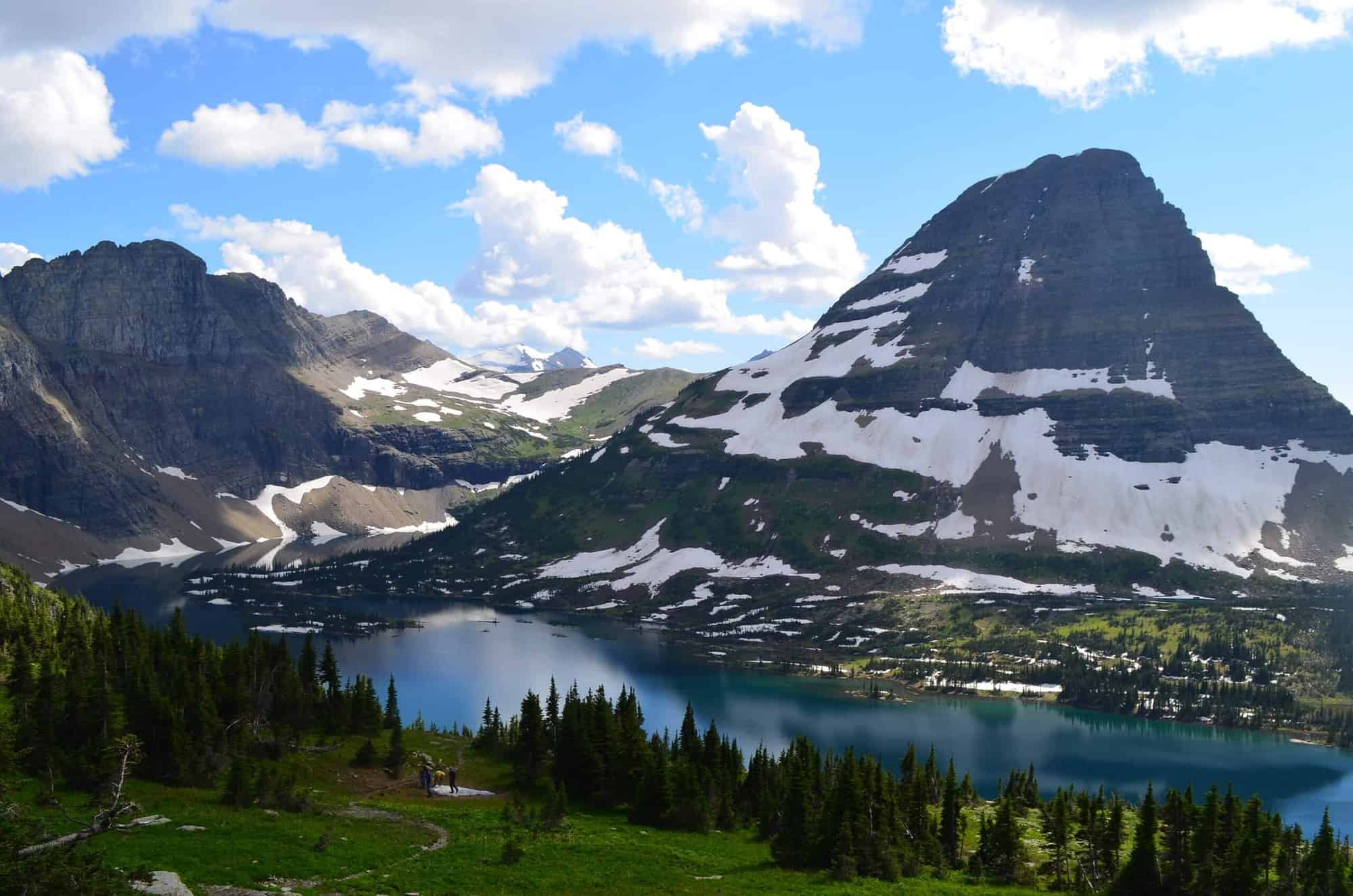
Swiftcurrent Lookout: Glacier’s Highest Trail Destination
At 8,436 feet, Swiftcurrent Mountain Lookout is the highest point reachable by maintained trail in the entire park. The CCC built it in 1936 for $7,500 — not in the standard wood-frame style, but with a stone foundation and flagstone-mortar roof engineered to survive extreme summit winds. It has been listed on the National Register of Historic Places since 1986, per HikingInGlacier.com.
From Many Glacier (most popular route): 16.6 miles roundtrip, 3,650 feet elevation gain. The first 4 miles are nearly flat through the Swiftcurrent Valley — passing Fishercap Lake at 0.3 miles, Redrock Lake at 1.7 miles, Redrock Falls, and Bullhead Lake at 3.4 miles. Then 33 exposed switchbacks gain 1,250 feet in 1.4 miles to the 8,436-foot summit. Views take in Heavens Peak (8,987 ft), Mount Wilbur, Iceberg Peak, the Garden Wall, and the entire chain of Swiftcurrent lakes thousands of feet below.
From The Loop trailhead: 12.3 miles roundtrip with 4,300 feet of elevation gain — shorter in distance but significantly steeper throughout.
Huckleberry Mountain Lookout: High Bear Density, High Rewards

Huckleberry Mountain Lookout stands at 6,496 feet and is reached by a 12-mile roundtrip hike with 2,725 feet of elevation gain. The trailhead is on Camas Road, 5.8 miles north of Apgar Village — about 20 minutes from the West Entrance and roughly 2 hours from the East Entrance, per Glacier Guides.
The route begins flat across McGee Creek, then climbs sustained through forest before opening onto a ridge traverse with panoramic views: Longfellow Peak (8,904 ft), Mount St. Nicholas (9,377 ft), the Whitefish Range to the west, and the Livingston Range to the east. The 1933 lookout structure sits on the National Register of Historic Places. Red argillite rocks with ripple marks more than a billion years old are visible near the summit.
Author and naturalist Doug Peacock — close friend of Edward Abbey and author of Grizzly Years: In Search of American Wilderness — staffed both Huckleberry and Scalplock lookouts from 1976 to 1984. His firsthand observations of grizzly behavior in this corridor shaped that book directly.
Scalplock Mountain Lookout: Built to Watch the Railroad
Scalplock Mountain Lookout (6,919 ft) was built in 1931 specifically to monitor the BNSF railroad and Highway 2 corridor for fires. The name derives from “scalplock” — a warrior’s topknot — and became official after the 1910 Essex Fire that devastated the area. The trail is 9.4 to 10 miles roundtrip with 3,079 to 3,347 feet of elevation gain, taking 5 to 6 hours for most hikers, per EnjoyYourParks.com.
The trailhead is at Walton Ranger Station on US Highway 2, approximately 28 miles east of West Glacier and 1 mile east of Essex, Montana. The route crosses Ole Creek on a suspension bridge at 0.6 miles, then climbs steeply through huckleberry-rich forest with no water on the trail or at the summit. The 1931 tower has been modernized with solar panels. Hikers who visited in summer 2025 confirmed the lookout is actively staffed with welcoming monitors.
Summit views encompass Mount Saint Nicholas, Salvage Mountain, Church Butte, Elk Mountain, Running Rabbit Mountain, and the Great Bear Wilderness stretching south. Doug Peacock also staffed this lookout from 1976 to 1984 alongside Huckleberry Mountain.
Numa Ridge Lookout: The Remote North Fork Tower
Reaching Numa Ridge Lookout (6,960 ft) requires a 90-minute drive on unpaved roads through Polebridge — Glacier’s off-grid North Fork community where there is no cell service. Fill your gas tank before leaving Whitefish or Columbia Falls; services in Polebridge are limited. The hike from Bowman Lake Ranger Station is 11.3 to 12 miles roundtrip with 2,930 to 2,998 feet of elevation gain, per NPS.gov. AWD or 4WD is recommended.
From the Bowman Lake Trailhead, hike 0.7 miles along the north shore before turning left onto the Numa Ridge trail. The first two-thirds are densely forested; the final third breaks above tree line with expanding alpine views. The trail is south-facing and fully exposed — start early and bring more water than you think you need. The 1935 lookout is actively staffed each season.
Summit views are exceptional: Bowman Lake far below, Rainbow Peak, Square Peak, Mount Carter, Moose Lake, and Akokala Lake in a wide panorama. Of the four staffed lookouts, Numa Ridge sees the fewest visitors by a significant margin — most hikers never make it to the North Fork at all, per Glacier National Park Travel Guide.

Unstaffed Lookouts: Apgar Mountain and Mount Brown
Two unstaffed lookouts offer the most accessible and most demanding experiences on this list.
Apgar Mountain Lookout (7.1 mi RT, 1,845 ft gain) is typically the first lookout trail to clear snow each spring — a good option for May or early June visitors. The trailhead is 0.5 miles from the West Entrance on Going-to-the-Sun Road, then 1.9 miles up a single-lane gravel road. The 1929 tower was rebuilt after the original burned just two weeks after completion. Views include the full length of Lake McDonald, Stanton Mountain (7,750 ft), Mount Brown, and Mount Cannon (8,952 ft). Note: a TV transmitter tower now shares the summit. The 2003 Robert Fire — a human-caused blaze that burned 110,000 acres and sent 500-foot flames across Howe Ridge — left dramatic standing deadfall visible throughout the climb, per HikingInGlacier.com.
Mount Brown Lookout (10.1 mi RT, 4,200+ ft gain) starts at the Sperry Trailhead across from Lake McDonald Lodge. The first 1.6 miles pass through old-growth cedar forest before a left turn at the Mt. Brown junction. The final 3 miles are brutally steep — hikers routinely climb on all fours on the switchbacks, per the 10Adventures trail database. The 1929 tower at 7,487 feet overlooks Heavens Peak, Sperry Glacier, and Lake McDonald 4,000 feet below. For experienced, fit hikers only.

Best Season and 2026 Planning Tips
The optimal window for fire lookout hikes is mid-July through mid-September. Lookout staffers are in residence, all trails are snow-free, and huckleberries ripen in late July and August. Snow lingers on the upper sections of Swiftcurrent, Huckleberry, and Mount Brown through late June — bring microspikes before July.
| Month | Conditions | Lookouts Staffed | Notes |
|---|---|---|---|
| May–June | Apgar clear; upper trails snow-covered | No | Bring microspikes above 5,000 ft |
| July | All trails mostly clear by mid-month | Yes | Wildflowers peak; highest waterflows |
| August | Optimal for all lookout hikes | Yes | Huckleberries ripe; highest bear activity |
| September | Excellent, uncrowded | Yes (early September) | Larch season begins; first frost possible at elevation |
| October+ | Snow returns to upper elevations | No | Unstaffed lookouts only; limited access |
2026 fee summary: $35 per vehicle, $20 per person on foot or bike (age 16+), $30 per motorcycle. Cash is not accepted at entrance kiosks — pay by card or use the America the Beautiful Annual Pass ($80). No backcountry camping permit is needed for day hikes. For overnight trips, permits are required through Recreation.gov and sell out months in advance, per NPS.gov.

What to Know About Bears on Lookout Trails
Glacier has one of the densest grizzly bear populations in the contiguous United States. Lookout trails pass directly through prime habitat — huckleberry fields, creek drainages, and forest edge. The NPS recommends these specific practices, per NPS.gov:
- Hike in groups of 4 or more. There are no recorded fatal grizzly attacks on groups of four or more in Glacier’s entire history.
- Carry bear spray in an accessible hip holster, not at the bottom of your pack. It is more effective than firearms at close range in documented encounters.
- Make noise constantly — call out “hey bear,” clap, or talk loudly. Bear bells are largely ineffective, especially in wind.
- Avoid dawn, dusk, and night hiking. Bears are most active in low-light hours and at feeding times.
- If charged by a grizzly: Stand your ground, deploy spray at 30 to 60 feet. If contact occurs, play dead — flat on your stomach, hands clasped behind your neck, legs spread to resist rolling over.
- Maintain 100 yards from bears and wolves. Federal regulations prohibit approaching closer than that.
For Huckleberry Mountain specifically: start early (before 10 a.m.), make extra noise through dense brush sections, and carry a full can of spray per adult — not one can shared between a group.

Frequently Asked Questions
Can you go inside a fire lookout in Glacier National Park?
Do you need a permit to hike to fire lookouts in Glacier?
Which fire lookout hike is easiest in Glacier?
How many fire lookouts does Glacier National Park have?
Is water available on lookout trails in Glacier?
How We Researched This Guide
- NPS.gov Glacier National Park — fees, alerts, bear safety, wilderness permits, 2026 visitor information
- NPS.gov Numa Lookout Trailhead — official trailhead data and staffing confirmation
- Forest History Society — 1910 Big Blowup fire history
- HikingInGlacier.com — trail distances and route descriptions for Swiftcurrent and Apgar
- Glacier Guides — Huckleberry Mountain bear density and trail details
- EnjoyYourParks.com — Scalplock trail data and 2025 staffer reports
- 10Adventures trail database — Mount Brown lookout trail data
- Glacier National Park Travel Guide — Numa Ridge access details
- Wikipedia / Osborne Fire Finder — instrument history and specifications
Trail conditions, staffing dates, and fees can change without notice. Verify current conditions at the park’s official website or visitor center before your hike. Lookout staffing schedules vary year to year based on fire season funding and NPS staffing levels.
Planning a fire lookout hike in Glacier? Check current trail conditions, entrance passes, and shuttle schedules at the official NPS site before…