Avalanche Lake amidst Glacier National Park's soaring peaks and dense evergreen forest.
| | |

Best Hikes in Glacier National Park When Going-to-the-Sun Road Is Closed (2026)

When Glacier National Park‘s Going-to-the-Sun Road is closed, the best hikes are Avalanche Lake, Trail of the Cedars, Swiftcurrent Lake, St. Mary Falls, and Apgar Lookout — all accessible via park entrance roads that stay open year-round. You don’t need the alpine highway to have an exceptional day on the trail.

Disclosure: This article contains affiliate links. If you make a purchase through these links, we may earn a small commission at no extra cost to you. This helps support YourNPGuide.com.
Avalanche Lake in Glacier National Park with cerulean water ringed by waterfalls and forested peaks
Avalanche Lake — Glacier’s most-hiked destination and accessible even when Going-to-the-Sun Road is closed.

Some links below are affiliate links.

#1
Best for Accessibility
Wooden boardwalk winds through ancient cedar forest along Trail of the Cedars in Glacier National Park

Trail of the Cedars Loop

4.8

Easydifficulty
0.9 miloop
~50 ftelevation
30 minest. time

Barrier-Free Section
Year-Round
Wheelchair Accessible
West Side
Why we picked it: Glacier’s most accessible trail — a portion is paved and barrier-free, per NPS.gov. It threads through an ancient western red cedar grove alongside rushing Avalanche Creek and connects to the dramatic Avalanche Gorge viewpoint.

The trailhead sits in the lower Avalanche Creek area off the west entrance section of Going-to-the-Sun Road — accessible before the seasonal alpine closure gate. The cedar canopy creates a microclimate that stays green and lush even when the high country is buried in snow. The gorge section at trail’s end offers some of the most dramatic close-up scenery in the park for minimal effort.

Insider tip: Visit early morning when mist rises off Avalanche Creek. The boardwalk through the gorge gets crowded by 10 a.m. even in shoulder season.
NPS Trail Info

#2
Best Overall
Turquoise Avalanche Lake in Glacier National Park surrounded by forested peaks and snowfields

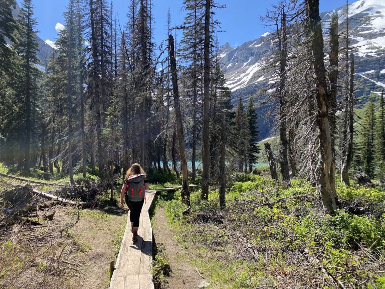
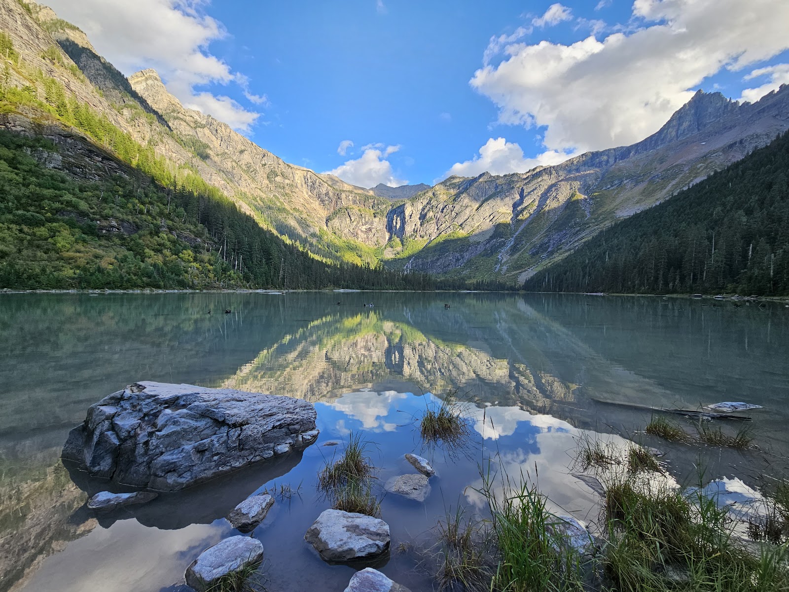
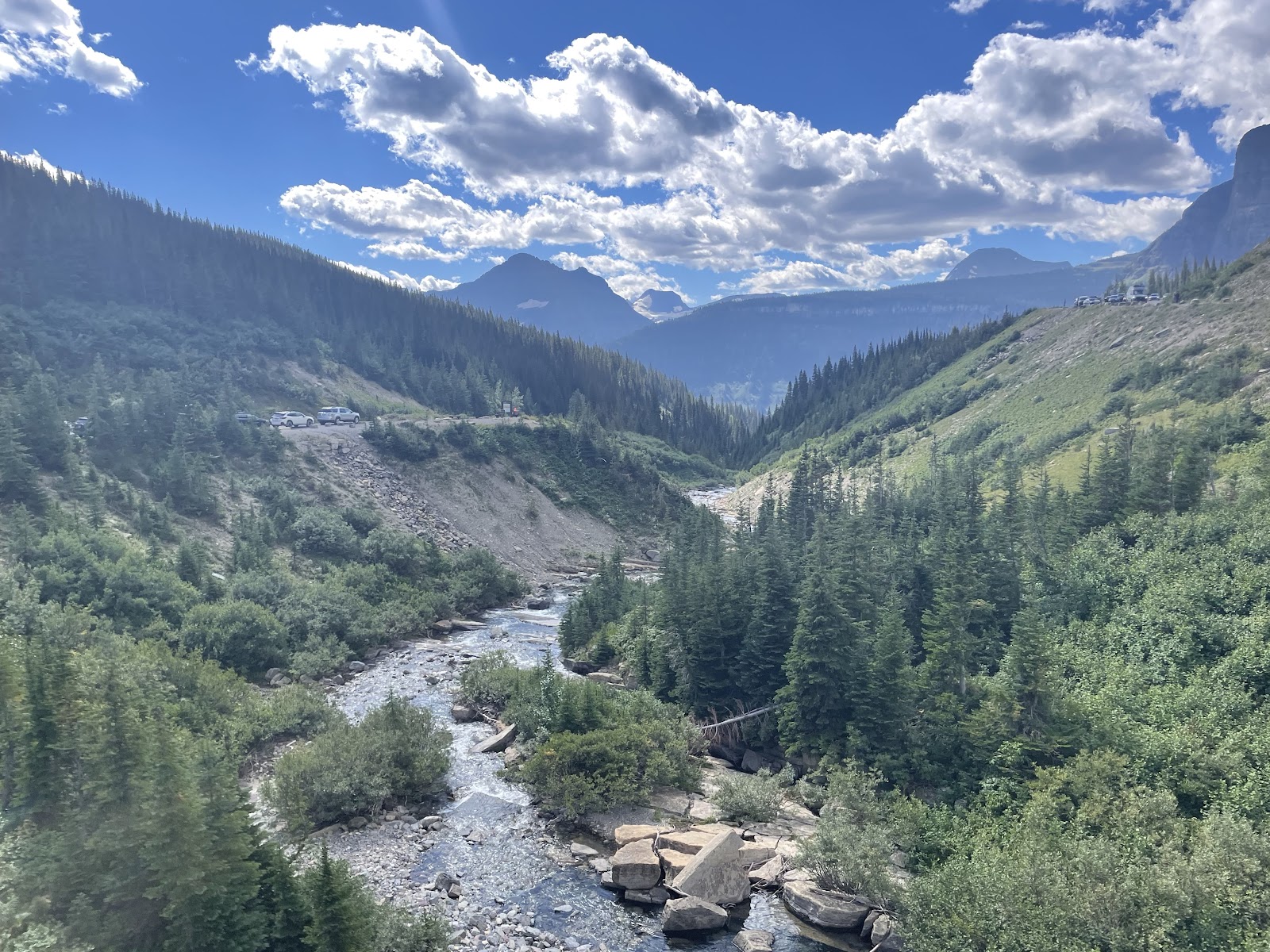
Avalanche Lake Trail

4.9

Moderatedifficulty
4.8 mi RTdistance
741 ftelevation gain
2.5–3 hrsest. time

West Side
Late April – Oct
Multiple Waterfalls
Bear Country
Why we picked it: Glacier’s most-hiked trail leads to a stunning cerulean lake ringed by five waterfalls cascading off sheer cliffs. The trailhead is on the lower west section of GTSR, accessible year-round before the seasonal alpine closure gate, per NPS.gov.

The trail follows Avalanche Creek through dense forest before opening to the lake basin at 3,905 feet, backed by towering peaks holding snow well into summer. The elevation gain is gradual, making it manageable for most visitors. Plan the full morning — this destination rewards those who linger. Elevation gain: 741 feet over 2.4 miles one-way, per AllTrails.

Insider tip: Arrive before 8 a.m. to secure trailhead parking. This is Glacier’s highest-traffic trail and the lot fills fast. Bear spray is essential — this is active bear habitat year-round.
NPS Trail Info

#3
Best Family-Friendly
Paddleboarder on calm Lake McDonald at Glacier National Park with mountain reflections in clear water

Rocky Point Nature Trail

4.5

Easydifficulty
~2 mi RTdistance
~85 ftelevation gain
45–60 minest. time

Year-Round
Kid-Friendly
Lake Shore
West Side
Why we picked it: A nearly flat trail leading to a rocky promontory jutting into Lake McDonald — with the famous rainbow-colored pebbles visible under crystal-clear water. Accessed from Fish Creek Campground off Camas Road, it’s open year-round, per NPS.gov.

Lake McDonald is 9.4 miles long and one of the park’s most visually spectacular features even without the alpine road open. The Rocky Point trail skirts the lake’s northern shoreline through forest before reaching a rock platform with open views of the lake and surrounding peaks. Kids love wading in the shallows and searching for the colorful stones.

Insider tip: Check out Lake McDonald’s rainbow-colored rocks — best viewed in calm, sunny conditions when the clear water is still. Late morning on a windless day offers the clearest views to the lakebed.
NPS Trail Info

#4
Best Easy East Side
Swiftcurrent Lake in Many Glacier area reflects towering cliffs and evergreen forest in Glacier National Park

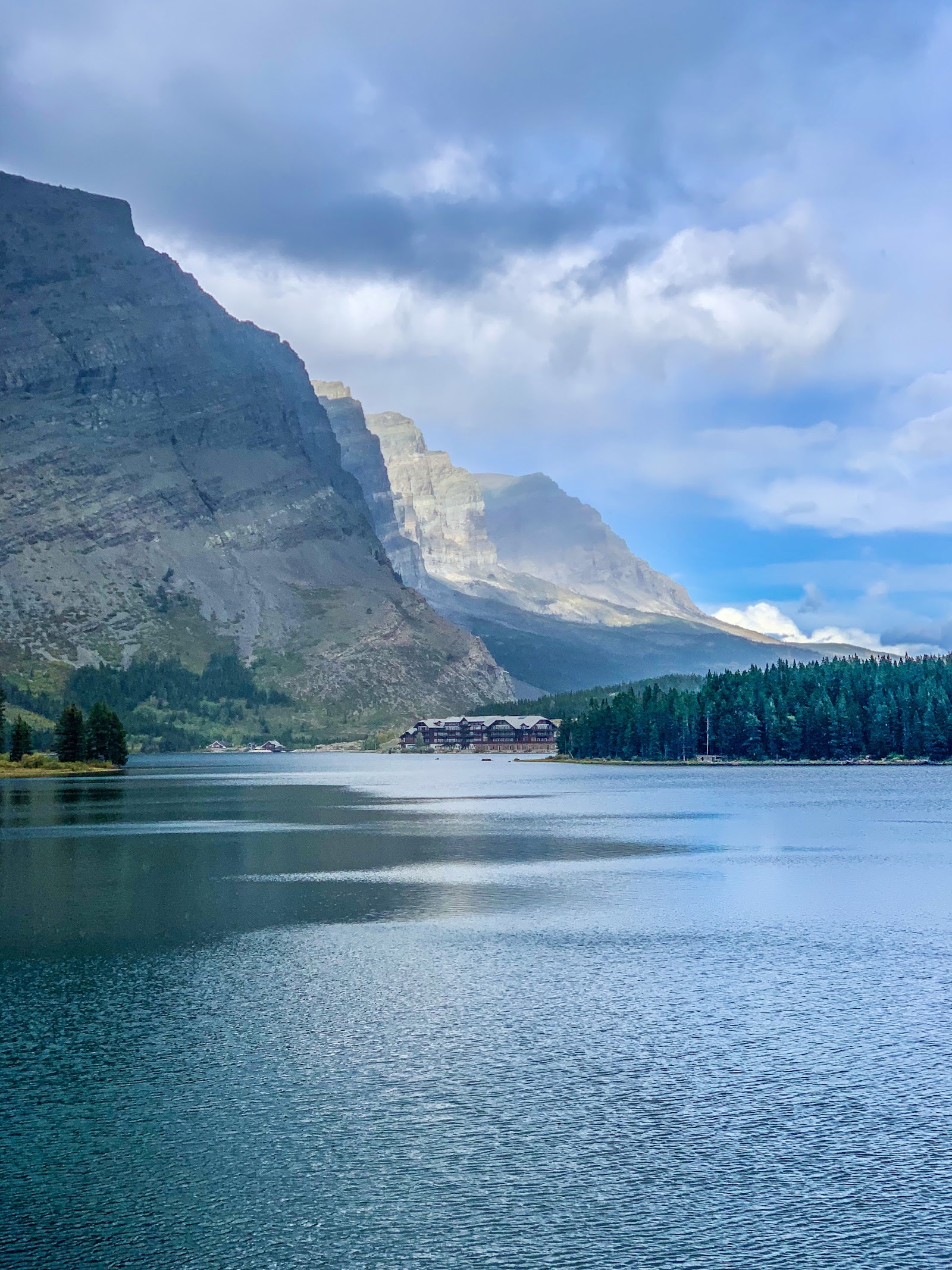
Swiftcurrent Lake Nature Trail

4.6

Easydifficulty
2.6 mi loopdistance
~100 ftelevation gain
1–1.5 hrsest. time

Many Glacier
No GTSR Needed
Wildlife
Late May – Oct
Why we picked it: Many Glacier has its own road off US-89 — it never requires GTSR access. This flat loop circles Swiftcurrent Lake with dramatic cliff reflections and some of the best grizzly bear, moose, and mountain goat sightings in the park, per NPS.gov.

The Many Glacier valley is Glacier’s crown jewel on the east side. This nature trail loops through meadows and forest with the iconic Many Glacier Hotel reflected in the lake. Wildlife activity peaks in early morning and evening. See our guide to Many Glacier with Kids for full area tips and easy trail options.

Insider tip: Many Glacier Road typically opens in late May or early June — often weeks before GTSR — making it a premier early-season destination when most of the park is still snowed in.
NPS Trail Info

#5
Best Waterfall Hike
Snow-capped Glacier National Park mountains overlook the St. Mary valley on the park's east side

St. Mary & Virginia Falls Trail

4.7

Moderatedifficulty
3.1 mi RTdistance
472 ftelevation gain
1.5–2 hrsest. time

East Entrance
Year-Round Access
Two Waterfalls
St. Mary Area
Why we picked it: Two waterfalls in one hike — St. Mary Falls drops 40 feet in a vivid blue cascade, while Virginia Falls above it nearly doubles the spectacle. The St. Mary east entrance stays open year-round with full visitor services, per NPS.gov.

The trail follows the lower GTSR briefly before dropping into the forested gorge toward the falls. Virginia Falls adds another 0.4 miles one-way beyond St. Mary Falls and is worth every step. Peak snowmelt (May–June) means peak waterfall flow — the most dramatic time to visit. The trailhead is 1.5 miles from the St. Mary Visitor Center, per AllTrails.

Insider tip: Add Baring Falls (0.5 miles from the trailhead, nearly flat) to your day for a third waterfall with almost no extra effort. All three falls can be combined in under 5 miles total.
NPS Trail Info

#6
Best Scenic Lake
Grinnell Glacier Overlook reveals turquoise glacial lake and snowfields in Glacier National Park

Grinnell Lake Trail

4.8

Moderatedifficulty
7.6 mi RTfrom hotel
~400 ftelevation gain
3–4 hrsest. time

Many Glacier
Turquoise Lake
No GTSR Needed
Late May – Oct
Why we picked it: Grinnell Lake turns a vivid turquoise-green from glacial rock flour suspended in the water — one of the most striking color payoffs in the park. Accessed entirely via Many Glacier Road (off US-89), no Going-to-the-Sun Road needed, per NPS.gov.

From Many Glacier Hotel, the trail passes through forest and open meadow before reaching the brilliantly colored lake below Salamander and Grinnell Glaciers. A summer boat shortcut crosses Swiftcurrent and Josephine lakes to reduce the round trip to just 3.4 miles. This trail also serves as the approach to the Grinnell Glacier hike for those wanting a longer day.

Insider tip: Take the boat to Josephine Lake if it’s running — best mountain scenery with a fraction of the foot travel. Boat tickets sell out; buy at the Many Glacier Hotel dock early in the morning.
NPS Trail Info

#7
Best Views
Alpine meadow with yellow wildflowers above tree line in Glacier National Park with mountain peaks in background

Apgar Lookout Trail

4.6

Moderate–Harddifficulty
~5 mi RTdistance
1,850 ftelevation gain
3–4 hrsest. time

West Side
Historic Fire Lookout
Panoramic Views
May – Nov
Why we picked it: This west-side trail climbs to a historic fire lookout tower with 360-degree views of Lake McDonald Valley and the park’s main peaks — the best panoramic payoff accessible without GTSR. The trailhead is near Apgar Visitor Center, which stays open year-round, per Enjoy Your Parks.

The trail switchbacks steeply through dense forest before breaking into open terrain with increasingly dramatic views of Lake McDonald and the surrounding valley. The summit lookout (5,236 feet) gives the widest possible view of the western park. A Volunteer in the Parks often staffs the lookout in summer and can identify landmarks from the deck. See all Glacier fire lookout hikes for comparison.

Insider tip: One of Glacier’s best fall hikes — October color and minimal crowds. Bring microspikes in spring when the upper trail can be icy well past April.
NPS Trail Info

#8
Best Quick Stop
Calm lake scene in Glacier National Park with pine-lined shores and mountain reflections in still water

Running Eagle Falls (Trick Falls)

4.7

Easydifficulty
0.6 mi RTdistance
Flatelevation
30 minest. time

Two Medicine
Wheelchair Accessible
Unique Geology
May – Oct
Why we picked it: One of only two barrier-free trails in Glacier, this leads to a geological marvel — a waterfall that falls through a hole in the rock at low water. Named for a Blackfeet warrior, it’s in the Two Medicine area (MT-49 off US-2), completely independent of GTSR, per NPS.gov.

The Two Medicine area is Glacier’s quieter east-side corner — far less crowded than Many Glacier. The flat paved path is suitable for strollers and wheelchairs. In spring snowmelt, both the upper and lower falls run simultaneously for the most dramatic display. The Two Medicine Lake viewpoint just past the falls adds only minutes to the stop.

NPS Trail Info

#9
Best All-Day Adventure
Turquoise Iceberg Lake surrounded by snow-capped peaks and sheer cliffs in Glacier National Park

Iceberg Lake Trail

4.9

Moderatedifficulty
9.6 mi RTdistance
1,210 ftelevation gain
4–5 hrsest. time

Many Glacier
No GTSR Needed
Floating Icebergs
Mid-July – Oct
Why we picked it: Floating icebergs persist in this lake even in midsummer — the north-facing cirque rarely gets enough direct sun to fully melt them. At 6,094 feet, the lake is surrounded by peaks exceeding 9,000 feet. Accessed entirely via Many Glacier Road (US-89), no GTSR required, per Hiking in Glacier.

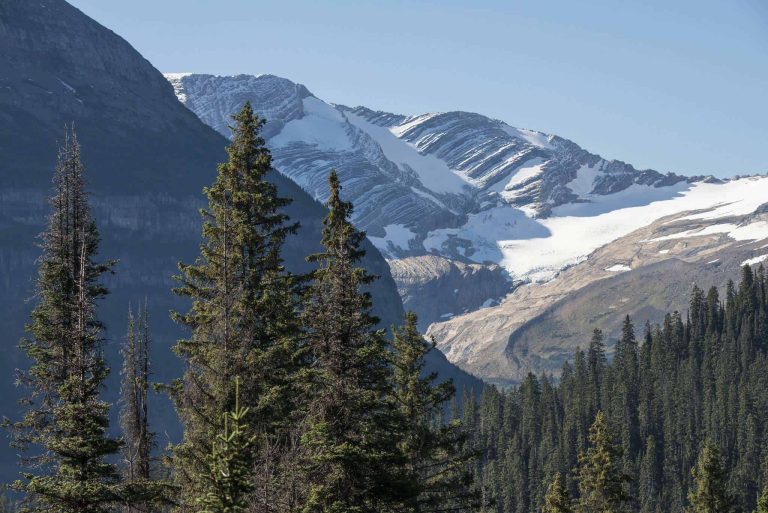
The trail climbs gradually through wildflower meadows and passes Ptarmigan Falls at the halfway point (5,660 ft) before reaching the lake basin. Best conditions are mid-July through September when the trail is snow-free. Note: this trail traverses an active bear corridor and is periodically closed for bear activity — check current conditions at the Many Glacier Ranger Station before heading out.

Insider tip: Start by 7 a.m. to beat both crowds and potential afternoon thunderstorms. Many Glacier parking fills quickly in summer. Bear spray is effectively mandatory on this trail.
NPS Trail Info

#10
Best for Solitude
Trail winds through green valley with evergreen forest and rugged Glacier National Park peaks above

Huckleberry Mountain Lookout

4.5

Difficultdifficulty
11.7 mi RTdistance
2,725 ftelevation gain
6–7 hrsest. time

North Fork / Camas Rd
Historic Lookout
Low Crowds
June – Oct
Why we picked it: One of Glacier’s longest day hikes, yet rarely crowded. Accessed via Camas Road off US-2 — fully independent of GTSR — it climbs to a staffed historic fire lookout at 6,593 feet with sweeping views of the North Fork valley and the Canadian Rockies, per Glacier Guides.

The trailhead is 5.8 miles up Camas Road from the Apgar area. After gaining elevation through dense forest and berry-covered slopes, the final miles break into open terrain with 360-degree views. A Volunteer in the Parks staffs the lookout in summer and can identify landmarks from the summit deck. Best after snowmelt, typically June through October.

Insider tip: Huckleberry sees a fraction of the foot traffic of Glacier’s marquee trails. For a big-mileage day without fighting for parking, this is the one. No water sources on the upper half — bring at least 3 liters.
NPS Trail Info

Frequently Asked Questions

When does Going-to-the-Sun Road close and reopen?
Going-to-the-Sun Road typically closes in October and reopens between mid-June and early July, depending on winter snowpack and spring weather. Snow removal crews begin work in early April, clearing approximately 40 avalanche paths across the 52-mile road. Check NPS current conditions for the latest opening estimates.
Can you hike in Glacier National Park in winter?
Yes. The lower west-side trails (Trail of the Cedars, Rocky Point, Apgar area) and the St. Mary east entrance area are accessible year-round. Most trails have snow and ice from November through April. Microspikes or snowshoes are strongly recommended. The $35 vehicle entrance fee applies year-round, per NPS.gov.
Do I need a reservation to enter Glacier National Park in 2026?
No. Glacier dropped its vehicle reservation requirement for 2026. You can drive in without advance tickets. Logan Pass parking is limited to 3 hours starting July 1, 2026. Entrance fees: $35 per vehicle, $30 per motorcycle, $20 per person on foot or bike, per NPS.gov.
Which side of Glacier is best when GTSR is closed?
Both sides offer excellent options. The west side (via US-2) gives access to Trail of the Cedars, Avalanche Lake, Rocky Point, and Apgar Lookout. The east side (via US-89) opens up Many Glacier, St. Mary Falls, and Two Medicine. See our full East Side vs. West Side comparison.
Is bear spray required in Glacier National Park?
Bear spray is strongly recommended on all backcountry trails and effectively required in bear-active corridors like Many Glacier, Iceberg Lake Trail, and Grinnell Lake area. Glacier has one of the highest grizzly bear densities in the lower 48 states. Carry it accessible at all times, not buried in your pack. Canisters can be rented at the Apgar Backcountry Office.
YourNPGuide Team
National Parks Research Team

Our team researches every trail, fee, and access condition using NPS official data, AllTrails reports, and verified firsthand accounts. All trail statistics and seasonal access windows are cross-checked against current NPS sources before publication.

How We Researched This Guide

Sources

  • NPS.gov Glacier National Park trail pages and current conditions (March 2026)
  • AllTrails trail statistics and difficulty ratings for Glacier, Montana
  • Glacier Tourbase 2026 GTSR access and ticketing information
  • Hiking in Glacier (hikinginglacier.com) — trail-specific mileage and elevation data
  • NPS 2026 Construction Updates — Two Medicine and St. Mary closure notices
  • Glacier Guides — Huckleberry Lookout trail conditions and staffing details
  • NPS entrance fee schedule verified March 2026 ($35/vehicle confirmed)
Data Checked
March 2026
Research Type
Synthesis of official NPS sources and verified trail databases
Limitations

Trail conditions change with weather, bear activity, and construction. Always check NPS current conditions before heading out, especially for Many Glacier and Two Medicine during early and late season.

Similar Posts